| Looking East from east side of Charlevoix Bridge Des Seigneurs Bridge in background |
|---|

|
Roger Kenner
Montreal, Qc,
Canada 2002
[Early Days]
[1999: Before Construction]
[2000]
[2001]
[Many items have been suppressed in this Lite Version]
In the early days of my riding along this section, I was not overly conscious of my surroundings, so taken was I simply with the excitement of riding along the water. I cannot recall, then, when the footbridge at Atwater was constructed. It was not until the early 1990s that I began to use it.
Unlike as is shown in the proposal, there never was a trail along the north bank, west of Des Seigneurs. The only trail was along the south bank, and that as far as the Cote St. Paul Locks. One can see here how bikes had to cross the busy Charlevoix Street, just as it came off the bridge.
Things are pretty much the same twenty years later. The rail yards next to Atwater Market are gone, but the tracks continue as far as Robin Hood Multifoods. Some condos have been built along the north bank, where in the beginning were factories (One of two Stelco installations, I believe). (I recall visiting these newly-built condos back in 1994, with Sheryl.
The bike path still has a troubled crossing at Charlevoix, and then runs behind what for long years was the Reader' Digest book bindery. The double path at the CN Bridge is shown in the map, but only the new section was open.
West of the Des Seigneurs Bridge, the Bike Trail went along the south bank only, in a narrow corridor between short, dead-end streets and the driveways and loading docks of warehouses on one side and the Canal on the other.
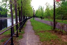
As the Trail approached the Charelvoix Bridge, there was a wider expanse of green, which could be used for picnics. In the background of the enlargement, the vacant lot on the north side can be made out. It was here that there used to be a small metalworks, the descendant of the Montreal Rolling Mills. The Charlevoix Bridge is one of the oldest crossings, dating from at least 1861.
| Looking East from east side of Charlevoix Bridge Des Seigneurs Bridge in background |
|---|
|
|
There was a tricky crossing at Charlevoix. Here the Bike Trail had to cross the road, and there was no light or stop sign for the cars. One had to wait patiently as the endless stream of cars would come across the bridge, and then race out at the slightlest chance. Typically, it was the combined weight of many cyclists at once which force the cars to stop. Woe be it to the cyclist who arrived alone. The nearby light at Charlevoix & St. Patrick was of little help, as cars would be turning right onto Charlevoix when it was red.
West from the Charlevoix Bridge, the Bike Trail ran again along a narrow corridor. To the street side was the back of the Reader's Digest Book Bindery.
| East along Trail from Atwater Charlevoix Bridge in background |
|---|

|
The view below shows the Canal looking east from the Atwater Footbridge. One can see the Charlevoix Bridge and the small parklike area to the west of it. On the North side is a vacant lot. In the background, on the east side of Charlevoix, is one of the old factories that have been refurbished into condominiums.
| Looking East along Canal from Atwater Footbridge |
|---|

|
Across from the Atwater Market, there was a small trail 'halte', at the south end of the footbridge. Before the renovations, there was a small parking lot there, with room for about half a dozen cars. Many times during the 1990s, Sheryl and I would park there and launch a ride eastward along the Trail with Alex or Tannissa. (This parking lot is now gone.). At various times, they have had small kiosks set up in this area.
A footbridge takes one across to the Market itself. This footbridge has been in place at least since 1989 (See Aerial Photos below). Many were the undocumented rides from home that had the Market as their destination. Sometimes, Sheryl and I would stop by there, and then our paniers would be so full we could hardly proceed homeward.
| Atwater Market From south side | Atwater Market From north side |
|---|---|

| 
|
Looking westward from the Atwater Footbridge, one can see the next bridge across the Canal, that of the CN main line, heading into St. Henri. The Trail proceeds only along the south bank. A vacant lot can be seen along the north bank, a lot which is now filled with newly-built condos.
| Looking West along Canal from Atwater Footbridge |
|---|

|
For many years, the Trail went under the CN Bridge on the Canal side, through a specially-constructed underpass which actually took one below the water level. When the railroad tracks along the south bank of the Canal were finally pulled up in the early 1990s, the old train underpass was left free. Soon the Bike Trail was re-routed in that direction and the old way closed off. It still remains visible, however.
| Trail looking West approaching Railway West of Atwater New Underpass | Original Railway Underpass Now closed off |
|---|---|

| 
|
Visible in the 1978 photo below, made just prior to the establishment of the Bike Trail, is the rail line along the south bank, and its underpass beneath the CN main line. There is no Bike Trail underpass, of course. Note the building just east of the CN Bridge, around which the Trail still curves. All of the warehouses and businesses on the south side and west of the CN Bridge are now gone. They disappeared early on. Clearly they were there in 1972, as Bernie and I walked along St. Patrick towards the Crane Industries Building.
There is no Atwater Footbridge, of course. The area east of the Market is a rail yard. The vacant lot on the north side, just west of the Market, remained so until only just recently.
One of the most welcome improvements along the Canal during the recent renovations was the construction of a Bike Trail underpass beneath the Charlevoix Bridge. This was made possible by the raising of the bridge, to allow for boat traffic. I watched its construction with interest, longing to end my age-long fight with the cars.
| Charlevoix Bridge: Construction of new underpass for Bike Path |
|---|

|
| Atwater Market: From south bank Note outline of old bridge |
|---|

|
I had never noticed before the clearly visible abutments of the old vehicle bridge at Atwater. The swing bridge was installed sometime between 1903 and 1912, at a time when Atwater Street went east of the Market. The current tunnel was not built until the 1950s (See Historical).
| Atwater: Old Bridge Abutments | |
|---|---|

| 
|
Visible in the photo below is the small 'halte' area along the trail at the south end of the Atwater Footbridge. The condos in the background were, for the longest time, just the empty, bare concrete shell of an old warehouse.
| Atwater: Footbridge Looking South Note outline of old bridge |
|---|

|
A single, lone rail line is all the remains of the myriad spurs that lined the north and south banks of the Canal in times past. This rail spur is kept alive by the Robin Hood flour mill, located on the north bank between the Des Seigneurs and Charlevoix bridges.
Note the new condos in the background.
| Atwater: Looking west along tracks on north bank Note apartments under construction in background |
|---|

|
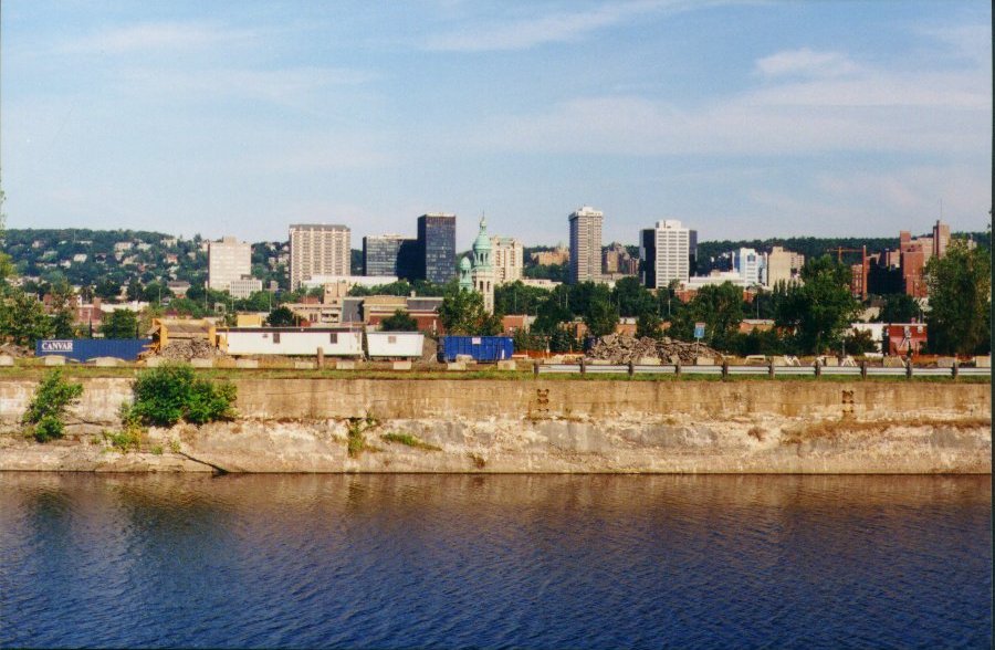
What had long been a vast, vacant lot, east of the Market, was primed for development in the Summer of 2001, as I rode by. I realized that it would be my last chance to get a photo of the skyline of upper town from that vantage point.
| Atwater Market: Last View from this angle Construction underway east of Market |
|---|

|
Today this area sports condominiums facing the Canal, with a new Super C supermarket behind.
| Atwater: Last Downtown View from this angle Construction underway east of Market |
|---|
|