Roger Kenner
Montreal, Qc,
Canada 2003
| Lachine: Westward Along Tracks |
|---|
|
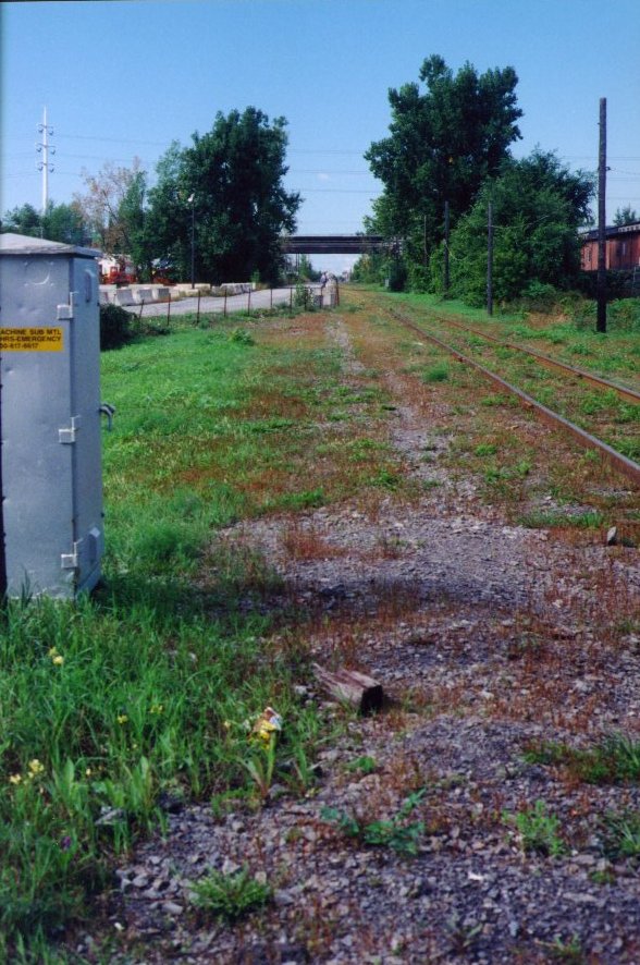
From the intersection of St. Jacques and Notre Dame, which marks the end of both of these boulevards, an old, abandoned bus route heads due west alongside the railroad tracks.
These tracks were once the main line of the Grand Trunk Railroad, but have now been reduced to an ever-shrinking spur.
The bus lane had been paved about ten to fifteen years ago, during a major overhaul of the Bridge/Hwy 20 interchange. It is now blocked off to vehicles, but bicycles are tacitly allowed to use the route.
| Lachine: Old Bus Route Looking West to CP Bridge |
|---|
 |
The first landmark one encounters is the steel bridge, resting on ancient-looking and massive stone embankments, of the CP main line, as leading over the St. Lawrence Bridge
| Lachine: Looking east along Bus Route from bridge | Lachine: Looking west along Bus Route from bridge |
|---|---|
 |
 |
| Lachine: CP Main Line Looking North | Lachine: CP Main Line Looking South |
|---|---|
 |
 |
The spur leading along the southern (LaSalle) bank of the Lachine Canal curves up to join the main line just south of the bridge.
| Lachine: CP Main Line Looking South (Enlargement) |
|---|
 |
West and north of the CP bridge is a track running down the embankment. Nowadays it is a storage spur for the train refurbishing factory, but it once was a major connection between the CP and CN main lines.
| Lachine: Tracks Climbing Towards CP Line | Lachine: Old Bus Route Looking East |
|---|---|
 |
 |
West of the CP Bridge, to the north, is the yard of what was the GE Locomotive Plant, but now seems to be a company that refurbishes old railcars. To the south are old, abandoned factories of what once was (within a few years ago) a thriving industrial park. There are several places where tracks used to cross the road, to lead into the factories. These are now paved over.
| Lachine: Train refurbishing factory | Lachine: Old abandoned industrial park |
|---|---|
 |
 |
| Lachine: Coming out at the end of Victoria |
|---|
 |
| The whole area has an aire of yesteryear to it. One feels the area has been forgotten since the 1950s. |
As the old GE Locomotive plant comes to an end on the north side, the private bus lane opens out onto the end of Victoria Avenue, at 1st Avenue in Lachine. The railroad tracks continue several more blocks, dividing Victoria Avenue, on the north side, from William MacDonald, on the south side. Long term parking is provided alongside the tracks. 1st Avenue cuts through here, from Hwy 20, where there is a bridge, to Rue St. Joseph, which is the main car thoroughfare into Lachine. Along the south side stretches a steel plant. Along the north side are the ends residential streets lined with small, modest houses.
Normally I ride along the north side, along Victoria. On the latest ride, though, I came along the south side, and encountered signs of the old streetcar tracks turning from what was the private right-of-way onto 6th Avenue.
| Lachine: Old Street Car Tracks at 6th Avenue Curve | |
|---|---|
 |
 |
The railroad tracks end at 10th Avenue in Lachine. This is far enough west to serve the spur that leads into the steel mill. These tracks represent the oldest line on the island of Montreal, being the original route for the Montreal & Lachine Railway. In later years, this was the main line of the Grand Trunk and CNR railroads.
|
|
Beginning at 10th Avenue, across from the park, a bike path takes the place of the old CN right-of-way.
|
| ||||
The bike path and Notre Dame (Lachine) approach each other at 18th Avenue, near the Lachine Market.
| Lachine: Old Lachine Market | Lachine: Looking east along Victoria Bike Path |
|---|---|
 |
 |
| Lachine: Old Factory along Victoria | Lachine: New Condos along Victoria Path |
|---|---|
 |
 |
| Lachine: Old time houses | |
|---|---|
 |
 |
 |
|
| Lachine: Cutting Through to Lachine Wharf |
|---|
 |
The old CN right-of-way followed the current Victora Avenue towards Dorval. There was a spur, however, leading to the Lachine Wharf. The current bike path follows this right-of-way towards the lakeshore, coming out at the Dairy Queen
|
|
| Lachine:Looking east along Canal from Crossing |
|---|
 |
| Lachine:Old Rail lines into Dominion Bridge |
|---|
 |
At one time, railroad tracks led from the Dominion Bridge plant, across the new bridge, to a tall steel warehouse structure located where the current Lock House is to be found.
|
| ||||
|
|
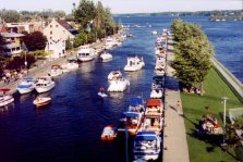
| Lachine Marina | Lachine Marina: Sailing Ship |
|---|---|
 |
 |
| Lachine:Bike Trail along Ile Monk | |
|---|---|
 |
 |
| Trail Through Pere Marquette Park |
|---|
 |
The Bike Trail crosses the locks and goes over a bridge onto Ile Monk.
Before the changes, the Trail continued along the south side of the Canal and crossed over by the marina. The Marina approach for cars was from St. Joseph. Upon reaching St. Jopeph, the bike trail went west along the sidewalk for fifty feet or so, before crossing a footbridge over the original canal and reaching Ile Monk.
Now, the bike trail parallels LaSalle Boulevard over the Canal and there is a new, diagonal footbridge, just for bikes, which reaches Ile Monk. The car approach to the Marina is now from the south side. There is no bike access across the Canal at the locks, except for walking the bikes over the locks themselves, which is permitted.
| Bridge Removed | |
|---|---|
 |
 |
| Lachine: New Footbridges in Place |
|---|
 |
When I rode by in the early Spring of 2002, I saw that all the footbridges connecting the Promenade P�re Marquette and the mainland had been removed. New bridges were in place by the end of the Summer.
| Trail Towards Lighthouse |
|---|
 |
After crossing over a footbridge to the mainland, the Trail runs along the sidewalk of the south side of St. Joseph. Over the years, more and more waterfront parks have opened up along this route. Just past the old Brewery, the Trail resumes its own right-of-way alongside the water.
| The 'Bateau-Bus' coming into Lachine Harbour |
|---|

|
The Lachine Wharf has long been a focal point of bike rides to Lachine. For many years I would ride with the kids along the length of Ren� Levesque Park, and then take the bateau bus from the point over to the mainland, right near the Dairy Queen.
The bateau bus has now changed its route. Leaving from the Marina, near the Locks, it is much less attractive a voyage.
| Training: Riding to the Lachine Lighthouse |
|---|

|
The Lachine Pier and Lachine Lighthouse have long been a destination for short rides. In days gone by, a stop at the Dairy Queen was de rigeuer on Summer rides.
| Lachine: Sunset from Lachine Wharf | |
|---|---|
 |
 |
| Lachine: Lighthouse-Wharf-Bridges from west of Pier |
|---|
 |
West of the Pier, the Bike Trail leads right along the water's edge through Parc Rolland.
|
|
| Lachine: Stony Point waterfront looking east |
|---|
 |
At Stony Point the thin riverside strip of parkland opens out into a wide and vast expanse of green.
| Lachine: Along the Waterfront at Stoney Point Park |
|---|
 |
It was here that the Tour de l'Ile had its relais each year that it followed the western circuit.
| Roger at Stoney Point Relais | |
|---|---|
 |
 |
| Sheryl at Stoney Point Relais | |
|---|---|
 |
 |
I can remember when, at the western end of Stony Point Park, between there and Summerlea Park, there used to stand a private home on the point. The bike path used to go up to the sidewalk to pass in front of the property. Some years back, the house was suddenly gone, but its traces remain.
| A house used to be here | |
|---|---|
| Seen from the east | Seen from the west |
 |
 |
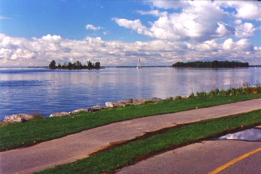
The last expanse of green in Lachine is Summerlea Park. As at Stony Point, one has an open vista out over Lake St. Louis, a vista that will not be repeated until one reaches Valois Bay.
| Lachine: Lake St. Louis & Dorval Island from Stoney Point |
Lachine: Lake St. Louis near Dorval Line |
|---|---|
 |
 |
The Dorval Line is marked by a wall of trees, markers of the private waterfront land ahead. The Bike Trail comes to an inglorious end and one is shunted over onto Lakeshore Boulevard.
Top


