| Ile Perrot: Coming in Along Hwy 20 |
|---|
 |
Roger Kenner
Montreal, Qc,
Canada 2003
Two days into my Summer vacation, I made the grand tour of Two Mountains, Oka & Hudson for the second time. This ride will be recounted in full elsewhere. Here, only the return portion, via the Lakeshore, is of interest. Nevertheless, it is possible to read the original description of the full ride. Little is changed below from the August, 1998 write up. Current comments are marked off in "[ ]"
Bike Ride: July 18, 1998
Loop up through Oka and across Ferry to Hudson
With Special detail on Two-Mountains-Oka Bike Trail
This is not the first time that I have taken this route. I made the ride last year, after having spoken with Claudia and Gilbert upon their return from this route (I met them by chance at Ste. Anne de Bellevue.) I have ridden up via the Oka trail many times. Once I took the trail with Sheryl. I have also been to Hudson several times. This is only the second time I have completed the loop with the ferry. This time I brought my camera!
It was day 2 of my summer vacation. I was anxious, no "hot" would be a better word, to get in a bike ride. Day 1 of my vacation had been spent writing. Sheryl was taking a course and would be busy all day.
This day I would get a late start, but would end up cycling for 13 hours in total. I made many, many stops, however. I took loks of photos and made lots of notes.
On the Way to Two Mountians
08:45 I got a late start....
[*The portion prior to returning along the Lakeshore is left out of this copy.]
Returning via the Lakeshore
I rode along across the northern tip of Ile Perrot...
I crossed the second bridge, onto the Island of Montreal, into Ste. Anne de Bellevue. On this bridge, one has to ride on the sidewalk of the old bridge. I think, however, that there is a segregated bike path on the far side of the new bridge. I took it once. Had I found my way through Terrace Vaudreuil, I would have been able to take it again. (the old bridge takes the highway eastbound and the new bridge takes it westbound.).
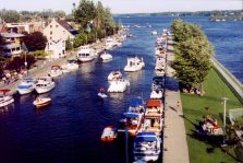
I stopped at the top of the bridge to watch all the boats waiting for their passage through the locks below the bridge.
It was 19:45 when I rode down into Ste. Anne de Bellevue. As it was late, and the boardwalk was very crowded, I decided to just ride along main street and head home.
At the edge of town, a short bike path leads across the campus of Macdonald College. One can escape the traffic for a ways as one rides across the green campus strewn with trees.
This bike path comes to an abrupt end at the Town of Baie D'Urfé line. Across Baie D'Urfé , one must ride on Lakeshore boulevard, and it is fairly narrow. Still, there is not much traffic, and there are lots of nice houses to look at, and lots of trees. The Lake is in the background. One goes through a large park as one rounds a cove. Past that is the quaint Town Hall, an interesting sight.
At the edge of Baie' D'Urfé, as one enters Beaconsfield, there is a fork in the road. The main road goes to the left and becomes Beaconsfield Blvd. This is not a very interesting way to go. The fork to the right follows the old Lakeshore Boulevard, along quite a number of quiet residential blocks. It is one way the opposite way, but the town had painted a bike path along half the road's width (A secret one, I might observe. There is no indication or signs leading to it. When coming from the east, it is easy to miss.)
At a certain point, the bike path and road end. One must turn left and ride up to Beaconsfield Blvd. For a mile or so, there is no choice but to follow this main road, as nothing more to the lakeward goes through.
At St. Charles Road, one can turn right again and follow the old Lakeshore Blvd. As it reaches the lake, there is a very nice, quiet park, right along the water [*St. James Park].
At the end of this stretch of Lakeshore Blvd, it rejoins Beaconsfield Blvd as the latter ends, and one enters the old time village of Pointe Claire. I tried to get some good shots of the church, but they did not turn out.
I rode out to the point to get a look at the lake. Though my binoculars I could see a freighter crossing the lake. Looking east, I could make out the Mercier Bridge, which one could hardly see with the naked eye.
I rode on. Soon I was rounding Valois Bay. Valois Bay curves far inland, to the point where Lakeshore Blvd is almost right next to the 20 for a few blocks. Then it curves back out.
On the far side, as one goes by Sources Road, one enters the town of Dorval. Dorval has a nice lakeside park at that point. It was 20:30 when I got to Dorval, and I stopped at the park to watch the sunset over Valois Bay. The church in Pte. Claire was now a very distant landmark.
The sun having gone down, I was racing home so I would not have to ride too much in the dark. I rode across Dorval in about 15 minutes, and got onto the bike path which starts at the Lachine line. I reached the old lighthouse in Lachine and called home to give my 30 minute warning, so that Sheryl could order the take out.
I took the inland bike path, which starts right next to the Dairy Queen. Since I discovered this path last year, I have used it a lot. It easily shaves ten minutes off the trip. It follows what was once a rail line down through the centre of Lachine. [*Indeed, what was the path of the original Montreal and Lachine Railway and what went on to become the Grand Trunk and CN main line up until the 1960s.]
I came out at the end of Notre Dame, rode through Ville St Pierre, up the hill into Montreal West, and along Sherbrooke to Monkland. I was home about 21:30.
I had ridden for 13 hours. It was not a fast day, as I made constant stops. I've done this route in far less time. But it was an intersting day.
Roger Kenner: August, 1998
| Ile Perrot: Coming in Along Hwy 20 |
|---|
|
| Ste. Anne: Bridge-Sidewalk Approach from Ile Perrot |
|---|
 |
| Ste. Anne: Looking out over the Channel, from the Bridge |
|---|
 |
| Ste. Anne: Boats in the Channel |
|---|
 |
| Ste. Anne: The Boardwalk & Quai Sera |
|---|
 |
| Ste. Anne: A Look down the Main Street |
|---|
 |
| Ste. Anne: Rustic House |
|---|
 |
| Ste. Anne: Bike Path across McDonald College Campus |
|---|
 |
| Ste. Anne: At the Baie d'Urfé Line Bike Path Ends |
|---|
 |
| Baie d'Urfé: Historic City Hall |
|---|
 |
| Baie d'Urfé: The Bay |
|---|
 |
| Beaconsfield: 'The Split' Old Lakeshore Road & Quiet Bike Path Or Beaconsfield Boulevard |
|---|
 |
| Beaconsfield: 'Start of the Bike Path |
|---|
 |
| Beaconsfield: St. James Park |
|---|
 |
| Beaconsfield: Lake View from St. James Park |
|---|
 |
| Pointe Claire: Town Line (West) |
|---|
 |
| Pointe Claire: The Church | |
|---|---|
 |
 |
| Pointe Claire: View East from Point: Dorval Island | Pointe Claire: View East at Valois Bay: Dorval Island |
|---|---|
 |
 |
| Pointe Claire: View East - Bridges (Binocular View) |
|---|
 |
| Pointe Claire: Freighter on Lake (Binocular View) |
|---|
 |
| Pointe Claire: Sunset View of Valois Bay - Looking East |
|---|
 |
| Dorval: Town Line along Valois Bay |
|---|
 |
| Dorval: Park along Eastern Shore of Valois Bay |
|---|
 |
| Dorval: Sunset on Valois Bay - Looking West | |
|---|---|
 |
 |