| Early Morning CN Locomotive on TMR Spur | |
|---|---|
 |
 |
 |
 |
Roger Kenner
Montreal, Qc,
Canada 2003
Foreword
It was an unseasonably warm Thanksgiving Weekend. After spending three of the four weekend days doing other things, I set aside Monday to make what would likely be my last day-long ride of the season. Rather than seek a distant goal, I decided it would be nice to explore in detail what was along the northern shore of the West Island. As I was recently doing the composite descriptions of previous rides, I realized how little I had explored beyond the confines of Gouin Boulevard. And even then, trips had been far fewer than along the Lakeshore, and the last visit had been in 1999.
08:30 I set off soon after sending Alex along on his way, leaving Sheryl to do her schoolwork. It was a chilly morning, so I was wearing sweater and windbreaker, even ear muffs. Within half an hour, though, I had doffed all of this accoutrement. The sun warmed things up quickly. I set out along my usual route to Cartierville.
09:00 While riding through the industrial park in TMR, I was lucky to come across an train engine and crew crossing the street along one of the spur lines.
| Early Morning CN Locomotive on TMR Spur | |
|---|---|
|
|
|
|
09:30 I reached the Lachapelle Bridge in Cartierville, after my usual one-hour ride. For the first time ever, I rode half a block east, to find and explore "Parc Belmont". This riverside park has a magnificent little boardwalk and provides a great vantage point for looking out on the river. It stands on the side of the former "Belmont Park" and commemorates this location by its name.
| Cartierville: Park Belmont | |
|---|---|
 |
 |
I headed west along the shoreline bike path, passing underneath the Lachapelle Bridge. Coming up on Rue Cousineau, the way is immediately blocked by the grounds of the Sacre Couer Hospital. Bikers must return to Gouin Boulevard.
| Cartierville Bridge: View Under Bridge | Cartierville Bridge: Path Under Bridge |
|---|---|
 |
 |
| Cartierville: Old Time House on Rue Cousineau |
|---|
 |
| Cartierville: Gouin - Near SacrÚ Coeur | |
|---|---|
| Looking East | Looking West |
 |
 |
10:00 Just on the other side of the hospital grounds is Parc Beausejour. I took a detour to explore the park. The path led down to the waterfront, where I saw a complicated series of bouys set out across the river west of the Lachapelle Bridge. I returned to Gouin along a different path through the narrow park, this one along its western edge, through a small forest, though backed by houses.
| Cartierville: River - Laval Shoreline - From Parc BeausÚjour |
|---|
 |
10:15 I reached Bois de Saraguay. As I approached the woods, the formerly wide Boulevard Gouin returned to its former two-lane status. East of the woods, on the river side, were a number of large, fenced, gated and treed estates. Alas, on the landward side, I was sad to see encroaching suburbia attacking the eastern flanks of the woods. One stately mansion, all boarded up, and grounds already sported the subdivision sign. Three of the five lots were already sold.
| Bois de Saraguay: Gouin Approaching Woods | Bois de Saraguay: Gouin Through Woods |
|---|---|
 |
 |
Along through Bois de Saraguay, Gouin showed its former quality of a narrow, country road. Fences lined both sides of the road, keeping everyone out of the woods. I was surprised to find one rural-style house, though, nestled in the trees.
| Bois de Saraguay: Rustic House in Woods along Gouin |
|---|
 |
| Bois de Liesse: Bridge over Creek at Mouth |
|---|
 |
10:30-10:45 After passing by the short six-block residential section that was the former town of Saraguay, I came to the Bois de Liesse Regional Park. I passed, and then doubled back to the small side street heading towards the river called "Avenue du ruisseau". It had looked inconsequential, but the sign indicating access to the park was a calling card. Just half a block down the street was a small bridge leading over a creek that emptied into the river. Beyond the creek began the park itself, although one or two private homes remained within its boundaries.
| Bois de Liesse: Creek Upriver from Bridge | Bois de Liesse: Mouth of Creek from Bridge |
|---|---|
 |
 |
Trails through the park led me to the river's edge...
| Bois de Liesse: Hwy 13 Bridge from River Access Point | Bois de Liesse: Power lines Cross River - East of Hwy 13 |
|---|---|
 |
 |
| Bois de Liesse: Laval Shore from River Access Point | Bois de Liesse: Mid-river Island in Fall Foliage |
|---|---|
 |
 |
...and then up alongside the creek, where there were a number of wooden lookout platforms, roofed like gazebos. The creek bed was little more than a wide marsh full of bullrushes. Park trails could have led me as far west as Boul. Sunnybrook, but I chose those which would bring me out at Gouin.
| Bois de Liesse: Creek Views | |
|---|---|
 |
 |
I came out at Gouin just as it was poised to go under the Hwy 13, and at the prominently announced Pierrefonds line. Before proceeding, I decided to explore a length of the trail on the opposite side of Gouin. The trail there followed the creek as it went under the highway. The section under the highway had been channeled like a canal, with steel boundaries on either side, and was swept clear of the thick covering of bullrushes that filled the creek on either side of the underpass. The trail I was following led to a parking lot on the far side of Hwy 13, along Gouin. Along the opposite shore of the creek led another trail, which must have been the one leading to Boul. Sunnybrook. I decided to turn around and go back to my starting point. On the way back, I passed a short side trail which led to yet another lookout/gazebo built out over the water of the creek. Just as I was coming back out onto the road, I saw a red fox. It crossed Gouin and vanished into the trees alongside the creek. I did not have time to get my camera out.
| Overpass at Pitfield & Gouin | Two Mountains Commuter Line - From Pitfield Overpass |
|---|---|
 |
 |
11:00 Returning once again to Gouin at the east side of Hwy 13, I set off to explore what seemed a strange thing. A freeway ramp came off of Hwy 13 to drop cars onto Gouin, and the ramp had a sidewalk. Why would a freeway ramp have a sidewalk? I rode up the hill along the sidewalk, facing the oncoming traffic, until I reached the top of the hill. I could see on the other side that the road was not just an exit ramp, but was also the frontage road to the highway. Effectively, I was on Boul. Pitfield. Looking southward from the high point, I could see the road descending to the businesses that lined the highway, and crossing Boul. Henri Bourassa, which was not too far away. Directly beneath me ran the CN commuter line heading towards Two Mountains.
I continued along Gouin, passing underneath the 13 and then passing by the ends of residential streets on the landward side and extensive hospital grounds on the river side. I was looking out for Boul. Lalonde, which would take me northward to run right alongside the river. As I came to the grounds of College Beaubais, I saw that all of the foreground of the college was being cut and shaped for new blocks of suburban houses. (This would be a constant theme throughout Pierrefonds!)
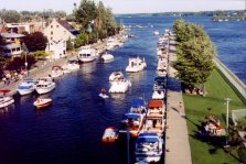
I finally came to Boul. Lalande and turned right, to follow it out past the college to the waterfront. There was a small marina and a delightful, though tiny, waterfront park.
| Saraguay West: Looking East along River from Marina |
|---|
 |
11:15 I stopped at the park for some cheese & cashews & raisins out of my small cooler. As I enjoyed my snack, I looked out over the wide vista of the river, which widened considerably at this point. Not too far distant, to the east, was the Hwy 13 Bridge. I looked across at Laval's Chemin du Bord de l'Eau shoreline, along which I have often ridden. From the river side one can hardly see the road for all the new housing developments. Where I was looking was near the beginning of Bord de l'Eau, just west of Hwy 13. The small marina, with perhaps a dozen open boats at dock, was a hub of interesting activity. I wondered if boat owners could get their boats out of this relatively calm portion of the river, on account of the rapids upstream. (I would later see a marked channel through these rapids, though I guess one would need a relatively powerful engine to run them upriver.)
I headed out along Boul. Lalande, which for several blocks was a delightful ride right along the river, with a well-groomed parklike promenade, full of flower beds, on the river side for pedestrians.
| Saraguay West: Promenade Boul. Lalande along Water's Edge |
|---|
 |
When I got to Rue Belvedere, I came upon a sign indicating that cyclist should turn away from the river and head inland. I decided to continue along Saraguay Est, which ran along the river, though now separated from it by one row of houses. I saw from the map that this street ended further up the shoreline, but I had hopes that there would be a minute passage for bicycles.
| Saraguay West: Lone remaining Summer Cottage |
|---|
 |
Alas, there was not. Saraguay Est came to an inglorious end, and all further movement west was blocked by a large hedge, the back yard of houses on the next street. At the time, I thought this was the Roxboro line and I cursed the city fathers for the elitism. (It turned out that the next street was still in Pierrefonds, part of the old district of Saraguay West. I backtracked along Saraguay West until I finally, after several long blocks, came to a pedestrian passage the next street. I thought I was in Roxboro, but I was only on Belmont, which dropped me back onto Belvedere, barely a block from where I had turned it down earlier. This had been an unproductive detour.
I quickly regained Boul. Gouin and continued west into Roxboro. Through the town of Roxboro Gouin is a wide, suburban and commercial boulevard of two lanes in each direction and divided by a concrete barrier. The businesses along the way, however, at the back of their small parking lots, are all rather dowdy looking. Curves at either end make for a short straight section throught the tiny town, but one cannot see any further in either direction. Along the river side were the ends of a series of straight streets, heading back to the river's edge. After my experience on rue Saraguay, I figured I had seen enough of dead-end streets, and so I passed them by. The opposite side was taken up by the massive parking lot of the Roxboro train station, backed by the slighly elevated rail line, which serves as a visible boundary.
It was only a few short blocks through Boul. Gouin's slice of Roxboro. Just before coming to the Pierrefonds line again, I noticed a bicycle route sign pointing down a small side street. The route led me almost immediately off road and onto a dedicated bike path, which ran through the woods and marsh near the river's edge.
| Roxboro/Pierrefonds: Bike Path east of Tracks | Roxboro/Pierrefonds: Bike Path through Woods |
|---|---|
 |
 |
12:00 The trail came to an abrupt end as it encountered a new housing project which was bulldozing its way into the forest. The just-dry concrete of sidewalks lining the new streets, themselves lined with half finished and tacky houses, cut right across the bike path. I was at the very foot of Sources Road, where it crosses the railroad tracks.
| Roxboro/Pierrefonds: Riverside Woods |
|---|
 |
| Pierrefonds: Housing Tracts Encroach on Riverside Woods | |
|---|---|
 |
 |
As it was Noon, I called Sheryl. Just as I was ready to set out, I missed the opportunity to catch a photo of the electric commuter train from Two Mountains, racing past the railroad crossing. I rode around the new traffic circle joining Sources with Riverdale, and then rode down Riviera to its end at 'Parc des Rapides du Chenal-Blanc', where I stopped for a few minutes to look out over the river and to change my film. I had first been by this way in 1974, by bike, and had returned once again by car around 1978, to buy a bird cage. I remembered the apartment buildings and a vast parking lot to the river side. It all looked different now. Even the apartment buildings did not look the same.
| Pierrefonds: Laval Shore from Rapids Park | |
|---|---|
 |
 |
| Pierrefonds: Beyond Riverdale: Soon-to-be-Gone Wilderness |
|---|
 |
12:14 - 12:45 I rode back up to Riverdale and out to the end of its four-land divided way, about half a block along. There was a gate at the end, with a vast open expanse of scrub forest beyond. The gate was ajar enough to permit cyclists and pedestrians, but to bar cars. All along the rest of the shoreline, east of the tracks, ran this isolated expanse of undeveloped land. Given Pierrefonds' penchant for development, it is sure not to last long. I rode along the road, which became a gravel road, and then two tire ruts through the trees. I knew it would come to an end at the railway bridge and hoped that there would be a way across, so that I would not have to backtrack.
| Pierrefonds: Wilderness Trail Beyond Riverdale | |
|---|---|
 |
 |
It did come to an end right at the bridge, right across from Ile Bigras. And there WAS an illicit crossing for pedestrians. Alas, the slope up the embankment was very steep, and I felt I would have trouble with the heavily-loaded bike. I decided to backtrack, back to the Sources Road crossing. It gave me an opportunity to take some of the pictures I had missed on the way out.
| Pierrefonds: CN Bridge to Ile Bigras | |
|---|---|
 |
 |
Along the western side of the tracks ran the very suburban street of Pavillon. I could only catch glimpes of the rail line, which ran behind the houses. Out at the end of the point, the collection of small streets got complicated. I eventually found my way to the quite undeveloped 'Parc des arbres', which was just across the tracks from where I had been earlier.
| Pierrefonds: Parc des Arbres - On the Far Side |
|---|
 |
| Pierrefonds: Front Yard Hommage to Trudeau |
|---|
 |
I continued westward, past quite massive homes built along the river's edge. Eventually, I found myself on Chemin de la Rive BoisÚ, which began to bring me back along the western shore of the peninsula, toward Boul. Gouin. This relatively quiet road was well shaded with trees and lined with magnificent upper-middle class homes sitting amidst spectacular lots. This was an area I had never explored before.
| Pierrefonds: Channel between Ile Bigras & Ile Perrot |
|---|
 |
13:20 I took a side trip to explore the tiny residential island of Ile Barwick, linked to the mainland by a small bridge and bristling with its dozen houses packed into the small space. The island offered a magnificent vantage point for a photo downriver. Just before coming to the island road, I had been forced to trespass to try and get a photo of the channel between Ile Bizard and Ile Bigras.
| Pierrefonds: Downriver View from Ile Barwick |
|---|
 |
As I was nearing the end of the more rustic suburban aire of Ch. de la Rive BoisÚ, I came upon a riverside park of the same name, and descended down to the river's edge, where I had a panoramic view of distant Ste. GeneviÞve and of the Ile Bizard bridge. Alas, the sun was in that direction, which precluded any good photos.
| Pierrefonds: Westward View from Parc de la Rive BoisÚ Ile Bizard Bridge in Background |
Pierrefonds: View from Parc de la Rive BoisÚ |
|---|---|
 |
 |
Immediately past the park began the construction zone for a whole series of new waterfront high rise apartments. I came back out onto Gouin, but before proceeding westward, I rode the one block up to Pierrefonds Boulevard, so as to document in photos the difference between the two. The official bike path of Pierrefonds goes along Pierrefonds Boulevard, a paved lane alongside the six-laned and open expanse.
Riding around the block, I was back at Gouin, at the foot of St. John's Road. From this point westward, Gouin runs right alongside the water of the small cove.
| Pierrefonds: Pierrefonds Boulevard at St. John's Road Official Bike Path |
Pierrefonds: Boul. Gouin at St. John's Road |
|---|---|
 |
 |
| Pierrefonds: Sprouting Waterfront Condos along Boul Gouin at St. John's Road |
|---|
 |
| Pierrefonds: Vanishing Rustic Waterfront along Boul Gouin at St. John's Road |
Pierrefonds: Sprouting Waterfront Condos along Boul Gouin at St. John's Road |
|---|---|
 |
|
| Pierrefonds: Vanishing Rustic Waterfront (Closeup) | |
 |
13:45 I stopped at a small roadside park, barely large enough for the picnic table, to get a better photo of the approaching Ile Bizard Bridge. Just a bit further on, I entered the town limits of Ste. GeneviÞve. The road narrowed and was lined with a much older style of home, many looking like they dated from colonial times. I was surprised to pass a couple of trailer courts! I was sure these had all been banished to the hinterland.
| Pierrefonds: Ile Bizard Bridge from Waterfront Park along Boul Gouin |
|---|
 |
| Welcome to Ste. GeneviÞve |
|---|
 |
| Ste. GeneviÞve: Plebian Sights on the West Island Imagine Trailer Courts (2 of them!) |
|---|
 |
| Ste. GeneviÞve: Boulevard from Ile Bizard at Boul Gouin Boul. Pierrefonds in Distance |
|---|
 |
13:55-14:10 I came to the Ile Bizard Bridge and decided to cross over and touch base on the other side. There had been a short time, in the early 1990s, when this had been part of my regular route to Two Mountains. I had not been back by bike since then. Originally, I had toyed with riding all the way around the island, but as the hour was getting late, I decided to just ride to the first intersection and then come back across the bridge.
| Ste. GeneviÞve: Ile Bizard Bridge from Riverside Park |
|---|
 |
| Ile Bizard Bridge: View Eastward towards Parc de la Rive BoisÚ |
|---|
 |
| Ile Bizard Bridge: Parc de la Rive BoisÚ Shore (Closeup) |
 |
| Welcome to Ile Bizard | Ile Bizard: Boul. Jacques Bizard - Looking Towards Bridge |
|---|---|
 |
 |
Once I was back onto Gouin, and going through the main part of Ste. GeneviÞve, I came almost immediately onto the new Cegep that had been under construction the last time I had passed (in 1999). While looking for good photography angles, I happened upon a hidden surprise. Behind the Cegep building is an old fortification town, and then a path leading down to a small park at the water's edge.
| Ste. GeneviÞve: CollÞge Gerald Godin - Modern | |
|---|---|
 |
 |
| Ste. GeneviÞve: CollÞge Gerald Godin - Traditional | ||
|---|---|---|
 |
 |
 |
| Ste. GeneviÞve: Historic Colonial Tower behind CollÞge Gerald Godin |
|---|
 |
As I passed through the rest of town, I stopped to get photos of the historic church and of the old main street. Then I was back into Pierrefonds. All through Ste. GeneviÞve, Pierrefonds, as identified by Pierrefonds Boulevard, lies only a couple of blocks behind the town.
| Ste. GeneviÞve: Historic & Majestic Church | Ste. GeneviÞve: Looking East along Boul. Gouin towards Church |
|---|---|
 |
 |
 |
The last section of Pierrefonds suburbia along Gouin is rather uninteresting, so when I caught sight of an interesting church structure inland along Pierrefonds Boulevard, I cut over to check it out.
| Pierrefonds: Majestic Church along Boul. Pierrefonds | |
|---|---|
 |
 |
Besides the church, I discovered quite a substantial hill, which I never knew existed. I rode across Pierrefonds and up several streets, to try to get to the top of the hill. I came out at Parc Yule, and rode up through the park until the trails ceased to climb. Nowhere was there a good, open vantage point, however. Only as I was coasting back down the side streets east of the park, did I come out just behind the church, where I had a good view.
| Pierrefonds: View Northward from Hill Behind Church |
|---|
 |
15:00 I continued out the bike path along Pierrefonds Boulevard until both came to an end at the busy cross street of Chateau Pierrefonds. Along the way I passed one remaining field of rows of vegetables, nestled in between the blocks of houses. The farmhouse and barn were at the other end, on Boul. Gouin. It was sure not to last much longer.
| Pierrefonds: Remaining Farm Lot amidst Suburbia - From Pierrefonds Boulevard |
|
|---|---|

|

|
| Pierrefonds: Remaining Farm Lot amidst Suburbia - From Boulevard Gouin |
|---|

|
| Pierrefonds: Pierrefonds Boulevard looking West from Farm |
(Close Up) |
|---|---|

|

|
I called Sheryl and then left my phone on. I still did not know when I would start back, though I knew it could not be much longer. I had set my sights on exploring the park at Cap St. Jacques a bit.
Looking out over the open fields west of Chateau Pierrefonds was troubling. All around were signs of the streets and housing pushing their way into these last remaining acres of open woodland and meadow. This would probably be the last time I would see this area as it had been.
| Pierrefonds: Extension of Boul. Pierrefonds past Chateau Pierrefonds Eating up the Last Farmland on the Island |
|---|
 |
I rode back to Gouin and proceeded west as the boulevard rounded the cove of Crystal Beach. All along the way, on the inland side, new developments were chewing up the farmland. Only a couple of farms remained.
| Pierrefonds: New Development Sprouting Everywhere | Pierrefonds (Crystal Beach): Roads Biting into the Last Farmland |
|---|---|
 |
 |
| Pierrefonds (Crystal Beach): Encroaching Development | |
|---|---|
 |
 |
| Pierrefonds (Crystal Beach): Last Rustic View along Gouin (This will soon be gone!) |
|---|
 |
On this more rustic stretch of road, there are many places where it runs right alongside the river.
| Pierrefonds (Crystal Beach): View over Water towards Cap St. Jacques | Pierrefonds (Crystal Beach): View Eastward along Boul. Gouin |
|---|---|
 |
 |
I finally arrived at Cap St. Jacques and followed the bike path right past the parking lot and into the park. I was surprised to find that there were still some private residences within the park. As I no longer had time to ride all the way out to the point, I cut across on the transverse pedestrian/bikepath/service road to come out at the "Plage" overlooking Lake of Two Mountains.
| Cap St. Jacques: View Eastward from Cape |
|---|
 |
>
15:40-16:00 I sat down on a rock at the beach and ate the rest of my cheese and a good portion of my nuts. This was despite the 'Defense de manger" signs. For such a popular beach, I was surprised at how tiny it was. I knew how the vast beach at Oka could become packed on a hot Summer's day. I could only imagine what the beach around this tiny cove would be like, being so much closer to the city. It was cool and blustery, and the wind was whipping up quite respectable waves along the shoreline.
| Cap St. Jacques: View Westward from Cape over Lake of Two Mountains | Cap St. Jacques: View of Beach Cove on Lake of Two Mountains |
|---|---|
 |
 |
| Cap St. Jacques: View of Beach on Lake of Two Mountains | |
|---|---|
 |
 |
| Cap St. Jacques: Beach Sign - Are they serious? |
|---|
 |
I studied the map and found a new, untraveled route to bring me home. I would cut inland along Chemin de l'Anse Ó l'Orme to Chemin Ste. Marie. This led eastward in a rather straight line through the centre of the West Island, becoming Hymus Boulevard past St. Charles Road. Hymus would bring me all the way into Ville St. Laurent, north of the airport.
16:10-16:15 On my way to take this route, I came upon the tiny waterside park at Anse Ó l'Orme. The park was thick with afficionados of a sport whereby people on waterboards are raced along by holding giant parasails. I tried to catch some photos, but the action was quick and I was often shooting into the sun. I also took some photos of the quaint, little settlement at Anse Ó l'Orme.
| Pierrefonds: Boul. Gouin across Cap St. Jacques |
|---|
 |
| Pierrefonds (Anse Ó l'Orme): Colonial House along Boul. Gouin at Cove |
|---|
 |
| Pierrefonds (Anse Ó l'Orme): Shoreline of Retreat North of Anse Ó l'Orme Park |
|---|
 |
| Pierrefonds (Anse Ó l'Orme): Sailboarding at Anse Ó l'Orme Park |
|---|
 |
| Pierrefonds (Anse Ó l'Orme): Sailboarding at Anse Ó l'Orme Park | (Closeup) |
|---|---|
 |
 |
| Pierrefonds (Anse Ó l'Orme): Sailboarding at Anse Ó l'Orme Park | (Closeup) |
|---|---|
 |
 |
| Pierrefonds (Anse Ó l'Orme): Sailboarding at Anse Ó l'Orme Park | (Closeup) |
|---|---|
 |
 |
| Pierrefonds (Anse Ó l'Orme): Anse Ó l'Orme Shoreline |
|---|
 |
| Pierrefonds (Anse Ó l'Orme): Boul Gouin through Anse Ó l'Orme |
|---|
 |
16:25 I came upon Anse Ó l'Orme Road, just past the bridge over the creek of the same name, and right at the Senneville line. It was high time to begin heading home. Luckily, the rather strong headwind I had been facing all day would now be behind me and I would be able to race along. There would even be some stretches when I would be cruising with the almost-never-used big gear in the front.
Anse Ó l'Orme Road was pretty empty. To one side was the creek and the park it runs through. To the other side were the open fields of Senneville. There were no buildings to be seen. I remember bringing my father this way in 1986, as he was looking for a place to park his camper trailer. There had been a camper park down along the river, under the trees. All trace of this was gone now.
When I came out into civilization, I was at Chemin Ste. Marie and in the town of Kirkland. A bike path alongside the Hwy 40 began right at the point where Anse Ó l'Orme Road met Ste. Marie Road. This I followed until I came to the Hwy 40 overpass. While the Kirkland side of the 40 was all suburban housing developments and big shopping centres, the south side was just an unbroken wall of trees. I wonder for how long?
| Kirkland: Bikepath begins along Ch. Ste. Marie |
|---|
 |
| Kirkland: Shopping Malls & Trees along Ch. Ste. Marie |
|---|
 |
I crossed up over the 40 and Ste. Marie became one way in the opposite direction, with a lane given over to a two-way bike path. It ran along behind the factories facing Hwy 40, with somewhat older homes and apartment buildings lining the south side of the street. The wind was pushing me along.
| Kirkland: Bike Path along Ch. Ste. Marie - Approaching Boul St. Charles |
|---|
 |
16:55-17:00 I came out at St. Charles Road. I would desperately have wanted a coffee, but there was no Tim Horton's or anything easily accessible. I headed west along wide, industrial Hymus Boulevard. At Stillview I came upon the end of what had once been CN's West Island spur line. The tracks had been removed, but the corridor leading between the backs of the factories facing onto Hwy 40 and onto Hymus was still clearly marked as CN property.
| Kirkland: Former End-of-Track at Stillview | Pte. Claire: Rails Still Exist at Doyon |
|---|---|
 |
 |
| Pointe-Claire: St Jean near Hymus: Street leading to end of track |
Pointe-Claire: End of track in there somewhere |
|---|---|

|

|
17:15 I came to St. John's road, just west of which is the Pointe Claire line. I crossed over and continued along Hymus. I did not take a detour to see if the railroad track came out as far as St. John's Road. I confirmed its presence only at Doyon, where the rails stretched as far as I could see in either direction. A police car passing slowed to investigate me standing at the railroad track writing in my little booklet. He did not stop me, however.
17:30 I crossed over Sources Road on Hymus. I then cut down to Chemin St. Franþois at the first occasion possible. Previously this had led through the open woodlands and meadowns north of the airport. In 1999, when I had first discovered the route, Ville St. Laurent's industrial park was just beginning to encroach upon the old road. Now, at Boul. Alexander Fleming, the old Ch. St. Franþois is completely cut off and blocked. It will soon disappear. I followed the old way, just for old time's sake. I rode down along the narrow, forest-lined road, where I had encountered a beaver dam in 1999, until I came out at the airport boundary and the road curved abruptly to the east. A bit further on was the far barrier, blocking traffic from using the road.
| Ville St. Laurent: Old Ch. Ste. Franþois Blocked Off |
|---|
 |
| Chemin St. Francois in Ville St. Laurent: New Road cuts diagonally |
Chemin St. Francois in Ville St. Laurent: Old road cut off by new |
|---|---|

|

|
| Chemin St. Francois in Ville St. Laurent: View Northwest from Corner |
Chemin St. Francois in Ville St. Laurent: View North from Corner |
|---|---|

|

|
| Chemin St. Francois in Ville St. Laurent: View Northeast from Corner |
|
|---|---|

|
Chemin St. Francois in Ville St. Laurent: View West from Corner |
Chemin St. Francois in Ville St. Laurent: View East from Corner |

|

|
| Chemin St. Francois in Ville St. Laurent: Rustic farm buildings |
|---|

|
| Ville St. Laurent: Soon-to-be-gone Farmland along Old Ch. Ste. Franþois (Now Blocked Off) | |
|---|---|
 |
 |
| Ville St. Laurent: Encroaching Civilisation (Closeup) | |
 |
|
| Ville St. Laurent: Closed off Ch. St. Franþois - By Airport |
|---|
 |
| Chemin St. Francois in Ville St. Laurent: View West from Junction of New Road |
(Close Up) |
|---|---|

|

|
I was a little concerned by a two men in a small red car who seemed to be hovering at the entrance to the old Ch. St. Franþois at Alexander Fleming, as if watching me. It was pretty deserted out in this industrial park on a Thanksgiving Day. I was able to ride past the barrier and down the road and left them behind. But when I came out at the other side, they were waiting for me. I got pretty nervous and took out my cell phone to call Sheryl. I hung up when I saw that they were really looking for something else. At least, I thought I hung up. Actually, I left the phone in communication with the house of half an hour, leaving Sheryl unable to reach me and running up who knows what kind of bill.
Chemin St. Franþois runs along the north side of the airport, cuts under Hwy 13 at the end of the runway, and then becomes MontÚe de Liesse and crosses Cote Vertu. I paused at the underpass to watch a couple of planes come in.
| Ville St. Laurent: Plane Approaching Dorval at Ch. St. Franþois Underpass | (Closeup) |
|---|---|
 |
 |
17:50 I reached Cote Vertu and headed east, back over Hwy 40 and along past the shopping centres until I came to Alexis Nihon, which I took south to the Hwy 40 crossing at the Kraft Plant.
18:20 Having passed through the TMR industrial park, I came out at Blue Bonnets. I cut across the tracks behind Wal-Mart/Decarie Square and headed home through Snowdon and NDG.
18:45 I was home.
Top