| Approaching new Wellington Bridge along South Bank |
|---|

|
Roger Kenner
Montreal, Qc,
Canada 2003
[1999: Before Construction]
[2001: In Construction]
[2002: Post Construction]
[Many items have been suppressed in this Lite Version]
From the inception of the Lachine Canal Bike Path, until the changes of 2001, the trail left the Old Port along wall of Rue des communes and crossed under the Bonaventure Expressway, where there was a small park on the north side of the Canal.
In my 1999 ride, I approached this area along the southern bank of the Canal from the Des Seigneurs locks, as I usually did. The trail passed behind the Redpath Refinery and then along the back of a newly renovated factory.
Where the junction with Wellington formed a triangle with the Canal, there was a park, formerly known as 'St. Patrick's Square'. In early years, it was completely enclosed by a fence and totally overgrown. One could see rusting, unused playground equipment sitting amidst the tall grasses. During the latest renovations, the park has been opened up.
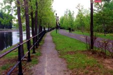
Before the Wellington Bridge was built, the only obstacle along that reach was the CN Railway Bridge. Over the Wellington Tunnel was a turn-off, so cyclists could get onto Wellington, but otherwise its passing under the Canal was unmarked. The new bridge, seen in the background, was built in the late 1990s.
| Approaching new Wellington Bridge along South Bank |
|---|
|
|
| Under Railway along South Bank |
|---|
|
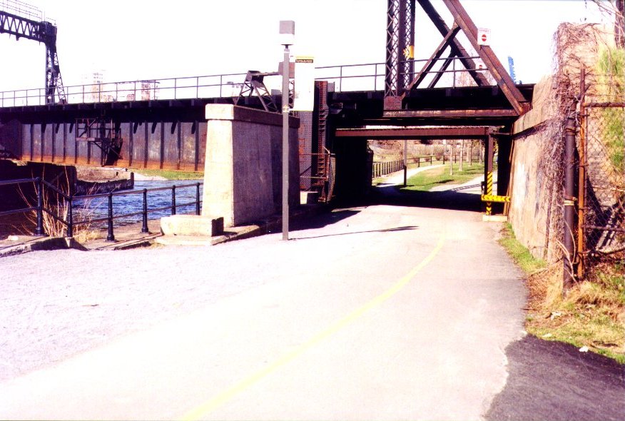
Passing under the CN Rail Bridge (which in the functional days had been a lift bridge: See Wellington Basin Historic), the trail crossed over a small footbridge spanning what had, in previous years, been a major basin. In the farground of the photo can be seen the end of the Canal and the footbridge leading to Old Montreal.
| Footbridge approaching end along South Bank |
|---|

|
The old crossroads: Continue to Cité du Havre or turn left towards Old Montreal. See the dam in the background.
| End of Trail at Harbour |
|---|

|
| Lachine Canal Control Gates at Mill Street |
|---|

|
It's a shame that overexposure has obscured the view beyond the expressway. It was under this dark way that the trail proceeded.
| Looping under Expressway towards Old Port |
|---|

|
The tranquil, park-like atmosphere shown in the photo below is no more. This area along the north bank of the canal, filled in during the 1960s, has now been completely dug out and returned to its original shape.
| North Bank of Canal at Harbour End |
|---|

|
Passing once again under the CN Rail Bridge, the trail then dipped under the new Wellington Bridge, before heading out along the straight reach towards the Des Seigneurs Locks.
| Under Wellington Bridge on North Bank |
|---|

|
Along the straight reach, the trail runs along behind the new, huge Canada Post complex and then its parking lot. In earlier days (See Des Seigneurs Locks Historic), there were a number of large basins here. At the eastern end, a spur leaves the trail to connect with the city streets, and it was here that I would often leave and catch the trail when going to and from work during the 1980s.
| View West along North Bank Des Seigneurs Locks in distance |
|---|

|
I did not return to the area with my camera until the Summer of 2001, and I saw many changes. Note the low level of the Canal water in this photo, compared with the one above.
| Wellington: Looking east towards Wellington Bridge from North Bank |
|---|

|
The Canal was blocked off just east of the CN Rail bridge, and the north bank trail no longer went through.
| Wellington: Earthen dam at CN Rail Bridge |
|---|

|
| Wellington: Historic Building |
|---|

|
The historic building above can be seen in the 1940 photo below, just behind the swing bridge. The lift bridge, whose corner is visible, is the predecessor of the current CN Rail Bridge. Once ship traffic ceased, there was no longer any need for a lift bridge.
The old swing bridge is locked in its open position. Behind it, a train crosses the fixed steel span of the CN Rail Bridge, where once there had been a lift bridge.
| Wellington: Old Railway Swing Bridge Train in background |
|---|

|
| Wellington: Remains of old tracks leading to Swing Bridge |
|---|

|
A small portion of the original track remains, where once the bridge would have swung over to connect. This, older rail bridge dates from the 19th Century, and was the first line to head into the Old Port (See Wellington Basin Historic).
The east branch of the old Wellington Tunnel remains. The centre streetcar right-of-way and the western tunnel were buried under the approaches to the new bridge. Although considered 'old', the tunnel actually only dates from around the 1930s.
| Wellington: Old Wellington Tunnel |
|---|

|
| Harbour End: Excavation work on Peel Basin |
|---|

|
Continuing along the south bank, the only trail open, one could see the vast excavation being undertaken along what was once the north bank. The Canal's flow had been reduced to barely a trickle.
| Harbour End: Excavation work on Peel Basin |
|---|

|
| Alex and I on bicycle outing |
|---|

|
It was a day for bicycling with my son, Alex. I am sure he felt it was a bit odd my stopping to take myriad photos of the construction zone
| Harbour End: Peel Basin View With city in background |
|---|

|
The last patch of green grass awaits the earth movers. The trees are already gone. The old footbridge is blocked off.
| Harbour End: Remains of Footbridge Across this bridge went the route towards Old Montreal. |
|---|

|
| Harbour End: Water trickles through cofferdams |
|---|

|
Barely a trickle comes through the Canal, past the many cofferdams that have been built, both here and further west.
| Harbour End: Looking West along Canal from End |
|---|

|
An entirely new path has been laid for the bike trail, crossing over the small dam at the Canal Overflow, near Mill Street.
| Harbour End: New Bike Path Route |
|---|

|
When I returned to the scene with my camera at the end of the Summer, excavation had progressed quite a bit. All that remained of the old footbridge was the barriar at its footings. There was no longer any opposite bank!
| Harbour End: Dead End on Old Route |
|---|

|
The shape of the old basin was clearly re-appearing. All of the old stone embankments had clearly been left in place.
| Harbour End: Work Progressing on Peel Basin |
|---|

|
The restoration work was clearly designed to return the area of the Wellington Basin to how it had looked before the Canal was closed. This is a laudable goal, though it was too bad that such a nice park had to disappear to achieve it.
The new plan for the Bike Trail, already in place by the Summer of 2001, saw the path continue along the southern bank of the basin, as far as the Outlet Dam. It then turned to the left and crossed the dam on a new bridge, before winding across the new, grassy expanse north of Mill Street.
The plan for the northern arm was not yet completed by the end of 2002. The trail was to run alongside the new basin, between the water and the CN embankment, until it met Rue des communes, which now cut through the embankment in a new underpass (restoring a link which had been broken in the 1930s, when the embankment was first built.). Alas, even though all the components were completed, the way was still cut off by a barrier underneath the CN Rail Bridge.
Those wishing to continue east from Wellington along the southern bank could now do so again. The way had been closed off for at least a year, on account of the construction at the Des Seigneurs Locks. Those wishing to travel east on the northern shore had to execute a complicated pattern over the Wellington Bridge. A circular path led up and around the embankment, onto the bridge's eastern sidewalk. At the northern side, another circular path led around to meet the old northern trail, just east of the bridge.
I took a ride down by the basin in the Spring of 2002, to see what had transpired, and found that all the excavation work was done. The bare basins were there, as was the new underpass. I rode along the side of the basin, but could not get through to the bike path because of the barrier. When I returned much later in the season, the barrier was still there.
| Wellington Basin |
|---|

|
| Wellington Basin |
|---|

|
| Wellington Basin |
|---|

|