| Trip Plan: Day 2: May 21 |
|---|
 |

Roger Kenner
Montreal, Qc,
Canada 2008
| Picture Key | |||||
|---|---|---|---|---|---|
|
|
|
|||
| [Read More] about the Picture Key. | |||||
| Trip Plan: Day 2: May 21 |
|---|
|
I was awake at 06:00. I showered before anyone else would claim the washroom and then set about re-arranging my paniers. (I had new paniers and learning to stow everything properly would prove to be a learning experience.) When I looked outside at the dark, grey skies, I could tell it would be another day like the evening before and so I made sure everything was properly stowed for a day of cycling in the rain.
By 07:30, I was down for breakfast and seated with a family from Sorel: A Hydro-Quebec worker, his wife and their son. 'Huguette' was more talkative in the morning than she had been the night before. She served up a great breakfast of eggs, ham, toast, and cretons. The breakfast conversation turned, naturally, to bicycle touring, as all were curious about my endeavor.
| Breakfast Room at Gite du Marquis: Jonquičre |
|---|

|
| Jonquière: B&B |
|---|
 |
Breakfast was done by 08:00 and I began packing up my bike. I carried my a bags down from the room and arranged them in the shelter of the steps, as much sheltered from the rain as I could get. In my repacking, I had placed all my rain gear at the top of the paniers. I pulled the yellow rain covers that came with my new paniers down over everything in the back. Since this cut any easy access to my rear paniers, I had to stow in the front paniers stow those things I would need during the day: My sweater, my leggings (for the cold), my wind breaker and my rain poncho.
| Jonquière: Morning View from B&B |
|---|
 |
Once I got my way at 08:30, I began by returning to the nearby IGA I had visited the evening before. This time I bought some water, some food and some ice for my small cooler.) It was 09:00 when I left the market.
Market, Jonquire IGA
| Jonquière Map |
|---|
| Street Map of Jonquière |
Between 09:00 and 10:00, I rode about my small corner of Jonquière. I started out riding back down along the short waterfront bike path, to its end at the dam. I rode across the dam, and a bit below on the far side, in order to get some pictures looking back. Then I rode back across and up from the waterfront to the main street.
(I would learn that this dam, le Barrage Joseph-Perron, was actually the first of three dams on the Rivičre des Sables as it stepped down the steep slopes into the Saguenay Gorge.)
| La Rivičre des Sables |
|---|
| Map of Dams on the Rivičre des Sables |
| Jonquière: Des Sables Dam: Bike Path Bridge |
|---|
 |
| Jonquière: Des Sables Dam: Spillway | |
|---|---|
 |
 |
| Jonquière: Des Sables Dam: View Downriver |
|---|
 |
| Jonquière: Des Sables Dam: Looking Back on Dam |
|---|
 |
| Jonquière: Looking Back on Downtown & Lookout Hill |
|---|
 |
| Jonquière: Looking over towards Factory |
|---|
 |
I came upon this sort of 'summit park' in the centre of old Jonquičre, a huge stone hill which towered over all the low building of the town. I was able to climb up to the lookout point at the top and have a 360-degree vantage view over the whole town.
| Jonquière: Lookout Hill |
|---|

|
| Jonquière: Parked at Lookout | Jonquière: Lookout at Centre of Town |
|---|---|
 |
 |
| Jonquière Lookout | |
|---|---|
| View West towards B&B | View South over Downtown |
 |
 |
| View East | View North over River |
 |
 |
| Jonquière Lookout: View over Downtown |
|---|
 |
| Jonquière Lookout: View over Railway Trestle |
|---|
 |
It waws 09:30 when I rode over to the nearby large, indoor shopping mall at the corner of Harvey and Saint-Dominique, where the stores were just beginning to open. My goal was to find some sort of clasp which would fix my nylon leggings to the bottom of my bike shorts. While these leggings, borrowed from Sheryl, were great at keeping my legs warm in the cold, they would soon inch down, leaving my upper thighs exposed. I almost ended up buying a garter belt, in order to pirate the clasps, but it was too expensive. In the end, I tried something from the dollar store, which did not end up working too well. I continued to have the problem.
By 10:00, I figured it was time to head on out of the town of Jonquičre. I continued east along Saint-Dominique until it became Price Street. The homes along the residental street became a bit fancier. I passed close by the huge Price paper mill complex, the steam of whose giant stacks had been a visible feature of Jonquičre during my visit. I passed a huge city park near the entrance to the mill, also named after the Price family. Thereafter, the road began a big, big descent, down into the gorge of the Saguenay river.
| Jonquière: Gates at Factory Entrance |
|---|
 |
| Leaving Jonquière: Descent into Saguenay Gorge |
|---|
 |
As I sped down down the steep descent, I knew that there would be payback later, but it was a great rush nonetheless. The road had widened, giving me lots of room, and my heavily-weighted bike was soon rushing along at almost automobile speeds.
At the bottom were the thunderous rapids of the Saguenay River. The angry water coursed through a stark, gravel riverbed, almost as one would find at the base of a glacier. The roadway crossed over the river in a new, modern bridge, but there was an older, abandoned one nearby.
| Leaving Jonquière: Bridge over the Saguenay |
|---|
 |
| Saguenay River: View Upriver to Old Bridge | Saguenay River: View Downriver |
|---|---|
 |
 |
| Jonquière Map-3 |
|---|
 |
| [See Larger View] |
On the way down, I had caught a quick glimpse of the white water exiting the massive dam upstream, but this view was lost by the time I got to the bottom. Before crossing, then, I decided to take a short detour along the road that led up the western side of the river. I got some close-up pictures of the old, overgrown bridge, and came around the corner to where I could get a vista of the dam.
| Saguenay River: The Old Bridge |
|---|
 |
| Saguenay River: View Upriver towards Dam |
|---|
 |
 |

|
| Jonquière to Alma Part One Map |
|---|
| Map of Jonquière to Alma |
By 10:15, I was back at the bridge and riding across. I stopped in the middle to take in the view of the river below, as it lunged its way towards its nearby rest at tidewater at Chicoutimi, barely a few kilometres away.
The road ended in a 'T' intersection just atop the short, steep ridge at the far end of the bridge. It was Route 174. I turned left on the busy, two-laned road and hugged the nearly non-existent shoulder as I slowly and labouriously began my climb up the eastern wall of the gorge. The cars and the trucks raced by me, for I was moving at only a snail's pace as I climbed.
Near the lip of the gorge, the road cut westward, angling up below a massive earthen dam. Then it turned back to its original direction as it closed the last remaining few hundred feet to the lip of the dam and gorge.
| Shipshaw: Chute ŕ Caron Dam: Climbing up towards Dam |
|---|
 |
Upon reaching the top, I crossed the road and pulled over to the edge of the dam. From there I had a good view back down into the gorge whence I had looked up at the same dam less than an hour before. I stayed there for many minutes studying the scene with my field glasses and getting as best photos as I could in the dark, stormy light. Across on the far distant side of the gorge, I could see this torrent of white water cascading down in a magnificent waterfall; it must have been that same quiet river alongside which ran Jonquière's little bike trail, la rivičre aux sables.
| Shipshaw: Chute ŕ Caron Dam: At the Top |
|---|
 |
 |

|
| Shipshaw: Chute ŕ Caron Dam: View of New & Old Dams |
|---|
 |
 |

|
| Shipshaw: Chute ŕ Caron Dam: View across Dam & Climbing Road |
|---|
 |
| Shipshaw: Chute ŕ Caron Dam: View down Gorge |
|---|

|
 |

|
| Shipshaw: Chute ŕ Caron Dam: View down Gorge |
|---|
 |
 |

|
| Shipshaw: Chute ŕ Caron Dam: Powerlines |
|---|
 |
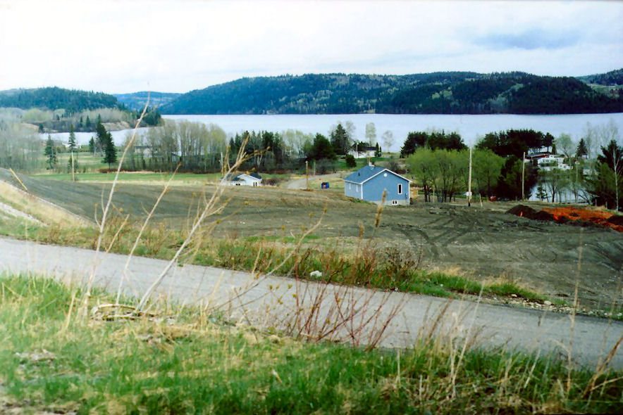
Continuing on my way at last, I reached the town of Shipshaw at 11:00. Above the dam, the waters of the Saguenay River were quiet and calm - like a long lake. Homes were built along both sides. I soon lost sight of the river, though, as the road underwent a series of ups and downs as it headed into town.
| Leaving Jonquière |
|---|
 |
 |
| Welcome to Shipshaw |
|---|
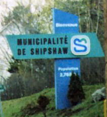
|
 |

|
| Shipshaw: Saguenay above Dam | |
|---|---|
 |
 |
I stopped at the far end of the small town, under the awning of a school that I could reach by riding my bike up the concrete ramp. I had to stop and remove my leggings and sweater for the rain had stopped and I was beginning to overheat. I kept the rest of my rain gear on, however. The resumption of rain seemed imminent.
| Shipshaw: Roadside Shrine |
|---|
 |
At 11:15, I was at the far end of the town of Shipshaw and heading back out into the countryside. The main highway, Route 174, took a turn to the right, to climb up higher and become more distant from the river. It appeared from my map that the smaller, unmarked roads, the rangs, would allow to me continue in a straight line, all the way to my distination of Alma without having to make the detour. I would also be closer to the Saguenay River, though still not in view of it. I would eventually discover that my choice had been in error. There were lots of deep ravines nearer the river and I found myself having to bike up and over a seemingly endless series of steep hills. Later, when the pavement gave out, I would find it very hard to push the heavy bike through the wet, sandy soil of the roadway.
At 11:40, and still optimistic about my route along Route Saint-Léonard (Rang 2), I crossed the town line of Saint-Ambroise.
| Welcome to St-Ambroise |
|---|
 |
| St-Ambroise: Rapids on the Des Aulnaies River: View North |
|---|
 |
| St-Ambroise: Des Aulnaies River goes over the Precipice |
|---|
 |
Half an hour later, at 12:10, I crossed into the town of Saint-Charles de Bourget.
| Welcome to St-Charles de Bourget |
|---|
 |
 |
| St-Charles de Bourget: Lakeside Cottages |
|---|
 |
I came to a crossroads where the sign indicated that Saint-Charles Centre was 2 km away, towards the river. The rang I had been following was along the high ground, but I could not see the river. I figured that two kilometres was about the right distance, and that old centre of Saint-Charles probably sat right on the water's edge. It seemed worth the detour, though I knew I would have to climb back up afterwards.
As I excected, the two kilometre ride was almost all downhill, except for the drop into one cross-ravine out of which I had to climb once again.
I was not long in Saint-Charles, from 12:30-1240. There was almost nothing there! It was a tiny, old collection of homes built around one big, wooden church. The town was almost on an island, so cut off was it by march-filled ravines all around. The cemetery in the tiny town was in preparation for a funeral at the church. Lines of cars parked around the church told me that the funeral must be in progress. The town had no businesses whatsoever, not even a depanneur. I did get my view up and down the Saguenay. The waterway was still calm, probably the work of the dam downstream. It seems about a quarter-kilometre wide at that point.
| St-Charles de Bourget: Dropping down towards Town Centre |
|---|
 |

|
| Saint-Charles-Bourget |
|---|
| Aerial View of Saint-Charles-Bourget |
| St-Charles de Bourget: Saguenay View | ||
|---|---|---|
 |
||
 |
 |
 |
| St-Charles de Bourget: Saguenay View |
|---|
 |
| Saint-Charles-Bourget |
|---|
| View of Saint-Charles-Bourget |
| Jonquière to Alma Part Two Map |
|---|
| Map of Jonquière to Alma |
Done with my excursion, I set myself to climbing back up the road. At the first side road, I decided it would be more interesting to take a different route back. The side road appeared to curve around and end up back at the high rang I had been following, just a bit further on. My new road turned to dirt almost at once. There was a sharp curve back towards the river and a drop to the bottom of another deep ravine. Now, much closer to the river, the ravines were quite pronounced, almost like canyons. I passed a few, isolated farms nestled in the ravine. Then the road turned up in the direction I had been heading.
| St-Charles de Bourget: Dirt Road Hell |
|---|
 |
I had no sooner rounded the curve and begun climbing up Rang 1 when I discovered I had a flat. Exasperated, there was nothing to do but unpack all my gear and flip the bike over to change the tube. I accomplished my work in record time, from 13:15 to 13:30, and then I packed all my gear back on and resumed climbing up the dirt hillside.
I became quite nervous for I was now without a spare tube. I had also seen that my rear tire was pretty well toast! The tread was completely bald and the remaining rubber was very thin. By 13:50, I had climbed back up to Rang 2, the road I had been taking before the detour. Signs at the crossroads indicated that I had progressed only two kilometres along my main direction towards Alma. My detour had been about 4km altogether.
| St-Charles de Bourget: The Long Climb back Up |
|---|
 |
At this crossroads, the pavement and the 'main road' took a turn northwards. The route I had intended to take further eastward would continue to be dirt road. As I looked eastward and saw the hills, I remembered the steep ravines I had been through recently and decided to abandon my plans of heading towards Alma along the back roads. I decided to follow the paved road and climb back up towards the highway.
| On 4e Rang: Blacktop & Hilltops |
|---|
 |
It was a gradual, but constant climb. Almost as soon as my wheels touched pavement, however, I felt a great sense of relief, and my legs thanked me. As I continued my climb, I came to realize just how high up the main road was. I reached the junction of Rang 4 and Hwy 174 at 14:35.
| On the Main Road-Route 172: Approaching St-Nazaire |
|---|
 |
 |

|
| On the Main Road: Valleys & Gullies |
|---|
 |
The sky had grown quite dark. It seemed like 19:00 or so. But at least it was not raining. Thank God! As I approached the town on the far hill, I noticed the beginnings of a shallow ravine through which the road threaded. I could see that it got more and more pronounced in the direction of the river. I guess this was the reason the main road was so high up and so far away from the Saguenay itself.
| On the Main Road: Valleys & Gullies |
|---|
 |
| Welcome to St-Nazaire |
|---|
 |
 |
It was 15:00 when I came into Saint-Nazaire. I stopped into a casse-croute at 15:05 for a snack, but once inside I decided not to risk my health by eating anything. I had a quick coffee for $1.40 and then was on my way again within 5 minutes.
Coffee, Saint-Nazaire
The highway threaded through and over some more hills. Off in the distance, I could see the plumes of steam rising from more pulp & paper complexes. Coming down once more out of the hills, I came to a 'T' intersection with Route 169 at a small collection of houses and gas stations called Delisle Junction. Alma was just over the hill, to my left, while to my right Highway 169 began its tour of Lac-Saint-Jean. The rain started as I was climbing up the hill towards Alma.
| Alma - Entrance |
|---|
| Map of Approach to Alma |
| Approaching Alma Map |
|---|
| Map of Alma Approach |
| On the Main Road: Descending towards Alma |
|---|
 |
| Alma Intersection: Looking back on Route 172 from Route 169 Junction |
|---|
 |
| Welcome to Alma |
|---|
 |
 |
| Alma: Bike Path on Road into Town |
|---|
 |
| Alma: Resort/Musuem at Visitor's Centre |
|---|
 |
Alma's tourist information centre was in a small resort/museum complex. By the time I reached the tourist office at 16:00, it was pouring rain. I stopped in to warm up and to have a friendly chat. I got a map of the town and was given directions to the town's only bike store, a big, modern store called 'Vélo Cité". It was Saturday and I knew the stores would close at 17:00, not to open until late morning (if at all) on Sunday. I also got directions to my B&B for the evening.
| Alma Tourist Information |
|---|
 |
Just over the hill, the road descended to the bridge over La Grande Décharge, the main outlet from Lac-Saint-Jean. This large waterflow ran at the base of a deep gorge, spanned high up by the highway bridge. Upstream, atop the hill over which I had just come, was yet another massive dam, holding back the waters of the lake. In the days before the dam, the water flow must have been impressive indeed!
I had encountered a bike path upon leaving the tourist information centre, and this path led me to cross the highway so as to cross the bridge along its downstream side, where there was a protected bike lane. Despite the rain, I stopped in the middle of the bridge to get a photo. My camera had been giving me problems. Only the Summer before, it had jammed and I had taken it for repairs. Now it was acting up again. The mirror would come down and stop. I would have to advance. the film in order to clear the jam. It finally gave out completely at the bridge. It jammed and I could not clear it. I had brought my wife's camera along as well, just in case. It was packed deep within my dry paniers and I did not feel like opening everything up to get at it. I left the photo, vowing to return the next day.
| Alma: View towards crossing La Grand Décharge |
|---|
 |
 |
| Alma: Bike Path across Bridge |
|---|
 |
| Alma: La Grand Décharge-Looking Downriver |
|---|
 |
At the far side of the bridge, the bike path dissolved into the back streets of Alma's suburbia, on a side street that paralleled the main road. I headed straight on in to the bike store, which was behind the town's big shopping centre. I got there at 16:30 and bought new tubes, a new patch kit and a brand new tire. I packed all these away, and then exchanged cameras in my paniers. The first picture on my wife's camera would be of the travelling fair that was set up in the parking lot of the shopping centre.
Alma: Velo Cite
| Alma: Fairgrounds at Shopping Centre |
|---|
 |
| Alma Downtown 1- Entrance | |
|---|---|
| Alma Downtown Street Map | |
My directions were via the main road, so I headed back over to meet it. So far, Alma had been fairly flat, but then I reached the lip of this steep descent. What had been a wide boulevard narrowed to two, busy lanes as I entered the older section of town. I was not really watching the side streets as I descended the steep hill, clamping down hard on my wet brakes to keep my speed under control. Once I had reached the bottom, I realized that I had overshot the side street upon which was located my B&B. I would have to climb back up! I hiked the bike the couple of blocks up the sidewalk.
| Alma: B&B |
|---|
 |
| Alma B&B |
|---|
 |
| [Qtourist Guide 2005 B&B] |
Saturday, May 21: Jonquière to Alma: ~ 50km Lodging in Alma: Gite Almatoit 755, rue Price 418-668-4125 818-668-4125 re: Jean-Guy Girard ($50) |
| [See Original Document] |
It was 17:00 when I reached the Bed & Breakfast, a big, Victorian home on a vast, tree-covered lot. It seemed so out of place amongst the tiny, wooden houses pressed tightly together all around it, like the manor estate. I met Jean-Guy, the innkeeper. The B&anp;B was called AlmaToit. It was a strange, yet beautiful house. All the interior was done in beautiful, natural wood, shined to perfection with oil. I would learn that there were two other guests. There was no key to be given, for there were no locks on the doors, not even the outside door. Jean-Guy had been waiting for my arrival, but now he had to go out. 'Help Yourself to a beer', he said. When I asked the location of restaurants like 'Mikes', he scolded me and said I could eat at Mikes anywhere. I was duty-bound to try out some local restuarants, and he gave me directions to a few.
After visiting my room, unpacking and changing into my cold weather gear (nylon leggings and sweater), I headed on out to explore around 17:30 to further explore Alma. I dropped down the back streets to the rapids of La Petite Décharge, an uncontrolled set of rapids that ran right through the centre of town. I wanted to get as many pictures of the marvellous rapids as I could; they had so impressed me as we had passed through the town a few years earlier. Still, I was working with an unfamiliar camera. After a few false starts with my wife's Nikon, I ended up having to change my first roll of film after only a few photos, due to a mis-understanding, I had thought the roll was full.
| Alma: Hill back towards B&B |
|---|
 |

|
| Alma: La Petit Décharge | |
|---|---|
 |
 |
| Alma: Pedestrian Bridge over La Petit Décharge |
|---|
 |
| Alma: La Petite Décharge: View Upriver |
|---|
 |
| Alma: La Petite Décharge: View Downriver |
|---|
 |
| Alma: Along La Petite Décharge |
|---|
 |
| Alma: Petite Décharge (2002 Views) | |
|---|---|
 |
 |
 |
 |
| Alma: La Petite Décharge: Flow past Downtown |
|---|
 |
| Alma Aerial View - Downtown |
|---|
| Aerial View of Downtown Alma |
| Alma: Church |
|---|
 |
| Alma Aerial |
|---|
| Aerial View of Alma |
| Alma: La Petite Décharge: View from Downtown | ||
|---|---|---|
 |
||
|
| Alma: La Petite Décharge: View from Downtown |
|---|
 |
| Alma: La Petit Décharge: View from Downtown |
|---|
 |
I rode through the tiny downtown and then climbed up the far side of the steep hillside, to find the restaurant Jean-Guy had suggested: Resto-Roberto. I got there at 18:30.
The waitress had a strange accent. When I asked what the daily soup was, it sounded like she said 'Creme de Menthe', which made no sense. When I repeated this incredulously, she looked at me in just as funny a matter. We finally negociated the meaning to be 'Creme to Tomates" I ordered soup, had a main course of spaghetti with vegetables, and downed a couple of beer. I called Sheryl while waiting for the food, and then it sat there for some time as we had a long conversation.
Alma: Resto Roberto
| Supper-Alma |
|---|
 |
| [See Original Page] |
I was not out of the restaurant before 19:30. Resto Roberto was perched high on the hill on the western side of the ravine of 'La Petite Décharge'. I could follow the new boulevard across its high span and could see all the way to the Petro Canada station where I had turned from the new boulevard towards the old route upon leaving the shopping centre a few hours earlier.
| Alma: View from Restaurant Hill |
|---|
 |

|
| Alma: View Downriver from Restaurant Hill |
|---|
 |
|
|
I made my way back down the hill and along and across the river by downtown, climbing at length up the back way to reach the B&B. I stowed my bike in the basement, as had been arranged with Jean-Guy, then I went up and took a nice, hot bath. I was just getting down with my bath when Jean-Guy and the other two guests returned.
He offered me a beer and we sat in the living room and talked for about an hour or so before I finally retired for the evening.
Top
Alma, Almatoit

![[See Larger View]](Keeps/Jonquiere_Cartotek.jpg)
![[Qtourist Guide 2005 B&B]](Keeps/BB01_Qtourist_LStjean2004_5.jpg)
![[See Original Page]](Keeps/Rest01_Qtourist_LStjean2004_5.jpg)