| Approaching Gauron Bridge |
|---|

|
Roger Kenner
Montreal, Qc,
Canada 2002
[Early Days]
[2000/2002]
[Many items have been suppressed in this Lite Version]
When I first rode the Bike Trail, starting in the east at Old Montreal, the Ville St. Pierre crossing merited hardly a glance. It was simply a bridge to cross along the way. From the earliest, the complete bridge infrastructure, with underpass and all, was in place. It was only when I began taking my Honda in for servicing at Clement & Lafleur that I had the idea to go to work by bike. And then later, living in NDG, the Ville St. Pierre access point became the most convenient.
The orignal plans called for a dedicated footbridge, but that was never built. The rail lines can be seen along the north bank, coming away from the canal near the bridge approach, but then returning behind the 'parkland'. These rails remained in place, below the embankment, until the early 1990s. I remember riding across them on Lafleur as I approached the 'Halte'.
The street network on the south side was a little different than today. It does not appear from the map that one could actually cross the interchange via St. Patrick.
I recall that, until quite recently, the main road coming off the bridge was Lafleur. It curved right and climbed the hill towards Clement. Only at the top of the hill could those wishing to cut over to Dollard make a left turn and go the half-block. It was not possible to connect directly via Dollard. Subsequently, they reversed the situation. Now the main road from the bridge is Dollard. Where Lafleur climbed the hill is now a park, with a bike path to make the connection. Those wishing to get to Lafleur now have to take the same half-block cutover, but in the opposite direction as before. I guess it shows the changing of the times. (Originally, Lafleur was the main road to the Mercier Bridge, before the building of the freeway.
The late 1990s map shows greater detail of the area. The recent renovation did not really touch this corner of the Canal, which is still the same today. There have been some changes to the surrounding area though. The major change from the earlier map is the absence of the rail line. Note the 'Resto Transert' which had long been a fixture at Lafleur and Notre Dame. It is now gone, and there is a Tim Horton's on the opposite corner. Lafleur still seems to curve westward in this map. The redirections which made Dollard the main access are still not shown (even in the most recent map).
Detail of the area is shown, but little has changed since the original planning of the Canal Trail. The CPR line along the Canal climbs up the embankment towards the main line. St. Patrick makes a curve that takes it beneath two, successing railway bridges. On the opposite bank is seen the CNR line
The late 1990s shows about the same situation. The 'Eastern Canada Ltd.' building is now gone. There was once a building to the west of this, behind which ran the Trail along a narrow right of way. That building has been gone for some years now.
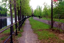
After the long, long ride from Cote St. Paul, the Gauron Bridge is a welcome landmark. Along the way, the factories to the right thinned and vanished, until one was riding alongside the highway. Then the highway veered away and there were more factories to the right. Then long stretched of shipping containers. Finally, the long buildings of what was once the Canadian Car Foundry. These are the immediate sign that the Ville St. Pierre halte is close.
| Approaching Gauron Bridge |
|---|
|
|
| Ville St. Pierre 'Halte' in Winter |
|---|
 |
The Trail crosses over to the south side at the bridge, in a complicated path involving an underpass.
| CPR Swingbridge |
|---|

|
The isolated section of the Path comes to an end at the CPR Rockfield Bridge, an impressive landmark. The Trail here swings under the bridge along its own 'bridge', coming out on the other side into a populated corner of LaSalle.
| CPR Swingbridge |
|---|

|
| CPR Swingbridge |
|---|

|