| Trip Plan: Day 9: May 28 |
|---|
 |
Roger Kenner
Montreal, Qc,
Canada 2008
| Picture Key | |||||
|---|---|---|---|---|---|
|
|
|
|||
| [Read More] about the Picture Key. | |||||
| Trip Plan: Day 9: May 28 |
|---|
|
It was 06:00 when I got up, to be upstairs for breakfast at 07:00. By the time I sat down for breakfast, my stuff was all packed up and the bags carried to the top of the stairs. All that would remain after breakfast would be for the innkeeper to fetch my bike from the garage. In this way, I could relax and have plenty of time to talk with my hosts.
Both the innkeeper and his wife were cooking for me. He made me some eggs and home-made sausage. We had a small language mistake. The woman asked if I wanted pain doré. I thought she meant "toast" (pain roti) and so said yes. Then I see her beginning to make French toast and had to correct myself. Breakfast was very pleasant, as usual.
My goal for the day was Berthierille. I would be crossing Shawinigan and then descending from the foothills down to the plain.
| Grand Mčre to Saint-Boniface Map |
|---|
| Road Map |
| Grand-Mere Map |
|---|
| Street Map of Shawinigan |
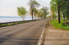
When I left at 08:30, it was raining. It was not truly rain, though. It was more of a clingy moisture, as if I were inside the cloud. The streets were wet and water beaded on everything. I made my way along the main street of Grand-Mere, 6e Avenue, which was also the continuation of Route 153. I could not see much through the mist and the moisture collecting on my goggles.
| Rainy Morning in Grand-Mčre |
|---|
 |
Shawinigan and Grand-Mčre were really just one town; there was no real break between them. 6e Avenue of Grand-Mčre dropped off the hill into an open commercial and industrial area between the towns, where it widened into a large boulevard called Boulevard des Hètres.
It was 09:30 when I entered Shawinigan proper. I had been riding for one hour, but had stopped briefly a couple of times, once into a doughnut shop to use the facilities and once under the abri of a small plaza to change my film out of the rain. Off in the distance, the eerie shape of some kind of mill began to take shape...
| Welcome to Shawinigan | |
|---|---|
 |
 |
| Shawinigan: Down the Hill |
|---|
 |
| Shawinigan: Distant Mill in the Haze |
|---|
 |
| Shawinigan: Curving to Pass by the Mill |
|---|
 |
As I approached the mill, the boulevard made a wide arc to the left, so that I passed right in front of it. Then, just as abruptly, the way turned to the right and followed Rue Saint-Marc through a working class neighbourhood. I had no idea where I was headed, so could only blindly follow the Route 153 road signs.
I dropped down off the heights and into a small valley, where I came to a viaduct over the railway, passing over the route that I had taken a week earlier. This would be my last view of this line until I would cross it again in Montreal.
| Shawinigan from Train (1 Week Earlier) |
|---|
 |
| Shawinigan: View from Viaduct |
|---|
 |
| Shawinigan: View from Viaduct |
|---|
 |
| Shawinigan: Over the Train Tracks |
|---|
 |
I did not know it at the time, but coming down off the viaduct I was on Rue Station. Soon I would pass by the old train station.
| Shawinigan: Old Train Station |
|---|
 |
A bit further on, as I was climbing back up from the valley, I came to a roundabout. The main boulevard obviously continued on into town; I could see the church steeple just beyond the rise. The Hwy 153 marker, alas, pointed to a road descending into a steep gorge. Had it been a nicer day and were I not already cold and wet from the rain, I might have gone on into town for a little look-see. As it was, I paused for a few moments to take some photographs and then descended the hill, bidding adieu to Shawinigan.
| Shawinigan: View from Roundabout |
|---|
 |
| Shawinigan: Mary at the Roundabout |
|---|
 |
| Shawinigan: Sharp Descent into the Gorge |
|---|
 |
The downhill ride would have been quite a thrill, except that I had to take care to work my brakes constantly as they were wet and I felt I needed to control my speed. I soon found myself deep in a narrow gorge, surrounded by old houses and a few old factory buildings. I was riding along a small creek, which I would later learn was the Rivičre Shawinigan.
| Shawinigan: Old Factory on Creek |
|---|
 |
Near the end of the gorge, where it came out on a bend of the Saint-Maurice below the falls, I came upon a large, grassy knoll and realized it would offer a great view from the top. I left my bike leaning against something and climbed up to the top of the hill. It was 10:00 and, mercifully, the misty drizzle that had accompanied me thus far began to lift even as I was looking back on the massive dams from atop the lookout. As the minutes passed, the distant views became clearer and clearer.
| Shawinigan: Looking Back on Factory Road |
|---|
 |
| Shawinigan: Tower and Old Powerhouse |
|---|
 |
| Shawinigan: Powerhouse at Foot of Dam |
|---|
 |
The road ahead curved around the shoreline of the cove. At the far end was an extremely steep hill, as the road climbed back out of the gorge, up to the level of the surrounding countryside. It would be a '4-stop' hill, which means I had to stop four times on the way up. I would look ahead to spot some object and then would expend the maximum effort to reach that point, at which point I would have to rest and catch my breath.
| Shawinigan: The Road Ahead; Around the Basin |
|---|
 |
| Shawinigan: Looking Back on Dam & the Gorge |
|---|
 |

|
| Looking Down the Saint-Maurice River from the Basin |
|---|
 |
| Goodbye St-Maurice: Looking Back from Lip of Hill |
|---|
 |
| Along Route 155: The Old Road Below |
|---|
 |
| Along Route 155: The Road Ahead |
|---|
 |
At 10:25, I was crossing the Hwy 55 freeway. Beyond the crossing, there was yet another big hill to climb before I reached Saint-Boniface at 10:50.
| Welcome to Saint-Boniface |
|---|
 |
 |
| Saint-Boniface: Church Statue |
|---|
 |
| Saint-Boniface: Gardens |
|---|
 |
| Saint-Boniface: Quiet Streets |
|---|
 |
| Saint-Boniface to Yamachiche Map |
|---|
| Road Map |
At the centre of the quaint, old town, Hwy 153 turned sharply to the left and began descending into the farmland. For the rest of the morning, the countryside would alternate between flat fields, just beginning to bud, and tree-covered ridges. I was 'in the rangs'. The only difference between the main road and all the other roads was the road marker - all seemed like back country roads. I kept being turned right and left at corners, as I zig-zagged my way towards Yamachiche and the junction with Hwy 138.
| Saint-Boniface: The Road Ahead |
|---|
 |
At 11:13, Yamachiche was 27km distant and Saint Barnabé was 10. I was coming out of the foothills and entering more and more into real farming country: There were fewer and fewer tree-covered ridges and more and more open fields.
| Along Route 155: The Beginning of Farmland |
|---|
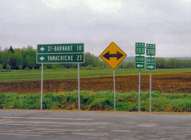 |
I reached Saint-Barnabé at 12:00. Yamachiche was still 14km distant.
| Welcome to St-Barnabé |
|---|
 |
 |
I finally came to the Yamachiche line at 12:30 and was at the centre of town, where I made the junction with Rte 138, at 13:00. I took a few minutes to explore the historical park at the centre of old Yamachiche before proceeding westward.
| Yamachiche: The End of Route 155 |
|---|
 |
 |
The ride along Route 138 was familiar to me, as I had pioneered it the year before. The highway led alongside the railroad tracks and into the wind.
| Yamachiche to Berthierville Map |
|---|
| Road Map |
My immediate goal was the A&W on the western border of Yamachiche, where I could have some lunch. Although this was only a few kilometres away, it seemed to take me forever to get there. I felt the wind in my face, but it did not seem strong enough to slow me down so much. I continued to slog my way across the flatland and finally pulled into the A&W parking lot. As I entered, I felt a sharp bump under my rear and only then noticed my flat tire. What bad luck! And yet, what good luck! At least it had waited until I was in such a perfect place to change it. Better at the A&W than out on the road.
| The A&W at Yamachiche (2004 View) |
|---|
|
|
|
|
I got to the A&W at 13:30. I would have my lunch - hamburger & fries, fix my flat and be on my way by 14:30. While eating, I crunched down on something hard. When I investigated, I found a huge chunk of my rear wisdom tooth had come off. I felt no pain (yet!) and had to search with my tongue to find the place where it had come off. At first I was not even sure it was a piece of my tooth.
Yamachiche: A&W, Lunch, Hamburger/fries
After lunch, I fixed my flat tire. Upon examination, I found a tiny piece of wire extending into the inside of the tire. I have no idea where I might have picked it up. My tire at full pressure, I set off down the road, and around the new traffic circle that had been put in place since a year earlier.
| Welcome to Louiseville | |
|---|---|
 |
 |
| River at Louiseville & Trestle | |
|---|---|
 |
 |
| Louiseville: Crossing Bridge - Approaching Church | |
|---|---|
 |
 |
Even though I could feel the wind against me, I was inspired by some kind of energy and seemed to be racing along. I came to Louiseville proper at 15:00. It is the only town through which the main road actually passes. All the other towns along that stretch are set off the highway.
| Louiseville: Main Street (2004) |
|---|
 |
|
|
| Louiseville: Western Border, Looking Back East (2004 View) | |
|---|---|
 |
 |
Upon leaving Louiseville, I came to a sign showning Meskinongé to be 6km and Montreal to be an even 100. I was feeling ever closer to home. (I recalled my first trip west, to Lancaster, in 1992, when I camped near a very similar Montreal: 100km sign.)
| Ahead to Maskinongé |
|---|
 |
 |
The highway ran parallel to the railroad tracks as I left Louiseville. I scanned the now clearing sky for signs of thunderstorms. The weather report had warned that the more the sky cleared, the more there was the risk of a local disturbance. I saw a dark spot on the horizon towards the northwest. I worried me. For a while I was sure I would be caught in the rain again.
| Along Route 138: A Passing Train |
|---|
 |
| Along Route 138: Distant Weather |
|---|
 |
I came to Meskinongé at 15:30 (yielding a speed of 12 km/hr). Meskinongé was just a bit off the highway. All that could be seen was the church steeple. Since the photo I had taken in 2004 had not turned out really well, I tried another. The next town, Saint Barthélemy, was a further 10km away and would be even further off the road.
| The Trestle at Maskinongé |
|---|
 |
| Meskinongé: Rail Trestle & Church (2004) |
|---|
 |
| Looking Back on Meskinongé (2004 View) |
|---|

|
 |
While between Meskinongé and Saint Barthélemy, I heard a distant train whistle. I stopped and waited the longest time before I was rewarded by the passage of a three-engine, mile-long freight train. Soon after the head of the train passed by, and as I moved on, the tracks began to curve gradually away from the road.
| Along Route 138: Up by the Tracks, Showing Highway |
|---|
 |
| Along Route 138: View South from the the Tracks, While Waiting |
|---|
 |
| Along Route 138: A Long Train Approaches |
|---|
 |
| Along Route 138: A Long Train Approaches |
|---|
 |
| Along Route 138: The Train Passes | |
|---|---|
 |
 |
| Along Route 138: The Train Track Curves Away |
|---|
 |
Just before coming even with Saint Barthélemy, I crossed officially into the Lanaudičre Tourist Region, the last tourist region before Montreal. I was feeling ever closer to home.
| Along Route 138 at Lanaudičre Line |
|---|

|
 |
I came to the Saint Barthélemy junction at 14:10 and, after riding past the small gas station/depanneur where I had stopped the year before, crossed Hwy 40 at 14:30.
| St. Barthélemy Centre in the Distance, from Route 138 (2004) |
|---|
 |

|
| Route 138: Hwy 40 Crossing (2004) |
|---|
 |
From the overpass, Hwy 138 stretched off in a straight line through the fields. Soon, though, I was riding past homes backed by the waters of the Sorel Islands.
| Route 138: On Towards the Saint-Lawrence & Berthierville (2004) |
|---|
 |
| Along the Water | |
|---|---|
 |
 |
| Berthierville |
|---|
| Berthierville Street Map |
I came to the small road turn-off (De Montcalm) from Hwy 132 at 17:00. Soon I met the main road (Rte 158) heading out over the bridge towards the ferry. At this point my path would diverge from that of my 2004 trip, but would coincide with that of my original 1990 bike ride. By 17:10 was standing at the old town centre (De Frontenac), by the marina. Memories of my riding around the town square back in 1992, looking in vain, in the pouring rain, for a restaurant, came flooding back. I also remembered our visit here with Sheryl's Miami friends, José & Madelene and family, when we ate at the marina.
| Berthierville: Town Square |
|---|
 |
| Berthierville: Marina |
|---|
 |
| Berthierville: River View East & Bridge | Berthierville: River View West |
|---|---|
 |
 |
| Berthierville Waterfront from Bridge (2004) |
|---|
 |
 |
I had no idea where the B&B might be. I was on De Frontenac Street and did not known where De Montcalm Street was. (I was unaware that I had been on it before.) I saw that the street address of the B&B was quite low, so I decided to ride west as the numbers decreased in that direction.
I rode quite a ways. always along the river, before the numbers descended to 890. Just at that point, I came upon what was left of the place where I had sheltered from the rain in 1990. The depanneur of the day was gone, but I recognized the balcony under which I had taken shelter from the rain and where I had wrung out my wet socks.
| Berthierville: 1990 Dépanneur & Shelter |
|---|
 |
The riverside road joined De Montcalm within a block and I only had to backtrack one block to find the B&B.
| Berthierville: B&B |
|---|
 |

|
It was an immense Victorian house, sitting back on a large property. Another, tiny home, complete with crosses and much other religious paraphanelia shared the back corrner of the property and the common driveway. Behind were farmers' fields. All was shaded by giant trees. The house had a full verandah and the innkeepers were seated out on it, as it awaiting my arrival.
They addressed me by name as I rode up. After I had stowed my main gear in my room, the lady invited me out on the verandah to have a beer and we sat and talked about my trip. She told me about the restaurants in town, including the Mike's out by the highway.
Berthierville: B&B
I phoned Sheryl soon after my arrival, to let her know that I had gotten to my destination.
I rode off around 18:30, deciding to play it safe and to head for the familier Mike's Restaurant. They offered exactly the kind of meal I had a hankering for. I rode east along De Montcalm until I came to Gilles Villeneuve Avenue. (He must have been from Berthierville, for I would also pass a museum dedicated to his honour.)
In the one kilometre I travelled out along Gilles Villeneuve Avenue and away from the river, Berthierville underwent a complete transformation. The quiet, sleepy town with stately tree-lined streets and Victorian-era homes became open strip malls, fast-food emporia, and big motels. I can recall having stopped in Berthierville once, upon returning with Sheryl from a trip out East. We ate in a modern truck-stop type restaurant as some huge motorcycle rallye was in progress and choppers and leather-clad drivers were everywhere. It was likewise as I rode out to the freeway end of town. Everywhere were big, shiny Harleys. I would discover that in the fairgrounds behind the Mike's was some sort of weekend rallye.
| Berthierville: Mikes & Motorcycles |
|---|
 |

|
Mike's was packed to the gills, but I managed to find a place at the bar and had the same special I had had a few days earlier: Star pizza with spaghetti and a special crepe-like dessert. (Soon, I would be giving up this contrabande once again, as my bike trip ended and my regular diet kicked in.)
At first it was somewhat hard to eat, as the couple in the very next couple of stools were going at it like they were in a motel room. It was hard to always have to glance away. There had been absolutely no place to lock my bike, so I ended up chaining it to the eaves trough drain pipe and leaning it against the big picture window of the bar. At least I could keep an eye on it as I ate.
I enjoyed my meal and the ambience of the restaurant bar from 18:30 TO 19:30. Afterwards, I rode around the active part of town for a few minutes, grabbing some photos of the motorcyle rallye.
Berthierville: Mikes: Pizza & spaghetti special, desert crepe, 1 large beer.
| Berthierville: Motorcycle Rallye |
|---|
 |
| Berthierville: Motorcycle Rallye |
|---|
 |

|
| Berthierville: Motorcycle Rallye |
|---|
 |

|
After a few minutes watching the show through a fence, I left and rode back in along Gilles Villeneuve Avenue towards the quiet part of town. Once again, upon crossing Route 132, all signs of busy activity ceased and I found myself once again on the streets of the tranquil, forgotten town.
At the foot of Gilles Villeneuve, by the river, was a small park. I was a quiet, peaceful place and I used the opportunity to call home and say goodnight to my Sweetie, whom I would be seeing the next day, although I could not predict exactly when.
| Berthierville Shore in the Evening: Looking East |
|---|
 |
| Berthierville Shore in the Evening: Looked West |
|---|
 |
After ending the call, I sat and watched the water. A local lady struck up a conversation with me, about how peaceful Berthierville was. When I mentioned the other end of town and the motorcycles, she retorted, "Il n'y a pas de motards ŕ Berthierville. Ils sont tous ŕ Lavaltrie." She then stormed off.
I rode back to the B&B and stowed my bike in the garage before retiring upstairs to a nice bath in their old-fashioned, footed bathtaub. As I was the only guest, I could take all the time in the world.
Top
